
How to Use a Map and Compass on Remote Trails of Nepal?
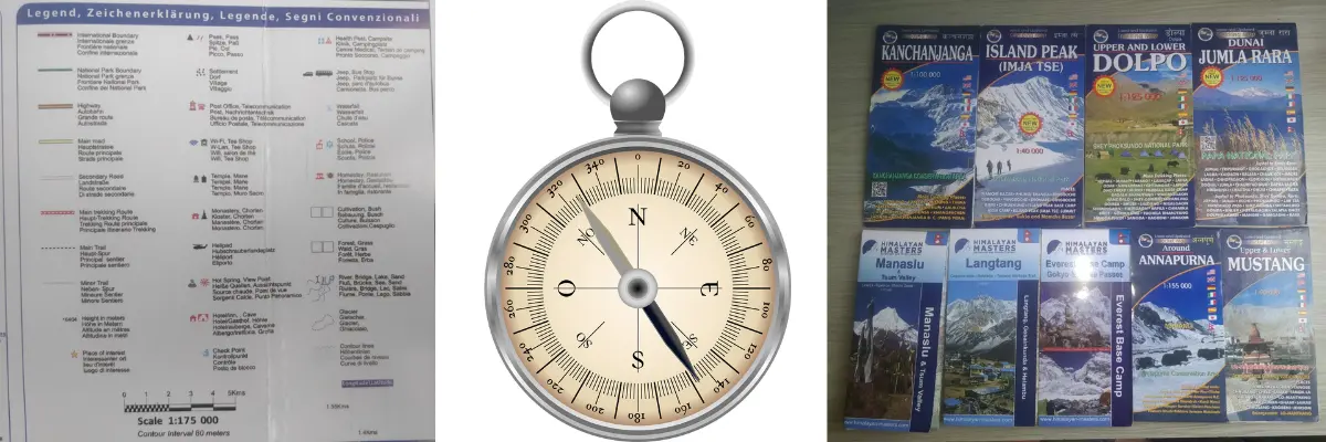
Table of Contents
Most of the time, most of the trekkers are worried about which is the ideal trek route for them, and what to pack and what not to. But, most of the time, they forget to pack and learn how to orient the map. Where even the GPS signals and mobile network fail, in such conditions, the only way to navigate is by knowing how to orient the map.
Offering some of the unmatched scenery and solitude, allowing connection with nature, Himalayan treks are just that magical. Whether it be the short and easy Langtang Valley Trek or the ‘hidden valley of happiness’, Tsum Valley Trek, trekking in Nepal offers a one-of-a-kind experience.
Trekkers on the Himalayan trails, especially modern, new trekkers, might be bewildered about how to find their way. That’s where traditional, conventional methods of navigation come into play.
Knowing how to orient the map and use a compass properly helps you navigate through local villages, forests, and high mountain passes. These age old tools are not just for mountaineers, but they are essential for any outdoor enthusiast out there.
Why Learning How to Read a Map is Essential?
While it’s easy and most of us are reliant on smartphones, learning how to read a map is an irreplaceable skill. The maps not only provide directions; they also provide an overall preview of the terrain.
It represents elevation, monasteries on the route, ridgelines, water sources, nearby villages, high passes, and major highlights nearby. Not only those, but it also shows potential risky areas like avalanche and landslide risk zones, which digital maps often miss.
When you know how to interpret a map, you unlock a different skill set. You begin to visualise the landscapes and make better decisions, especially in unfamiliar or emergency situations.
A map allows you to identify where you’re standing, where you’ve come from and where you’re headed. This kind of situational awareness is impossible to understand when digital maps can’t even pinpoint your location.
Moreover, when the weather turns bad or the trail becomes faint, reading the contours, symbols, and orientation of a map can literally be a lifesaver.
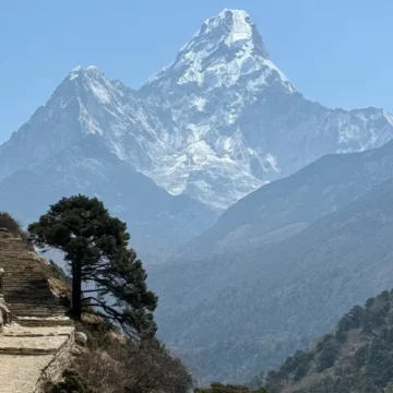
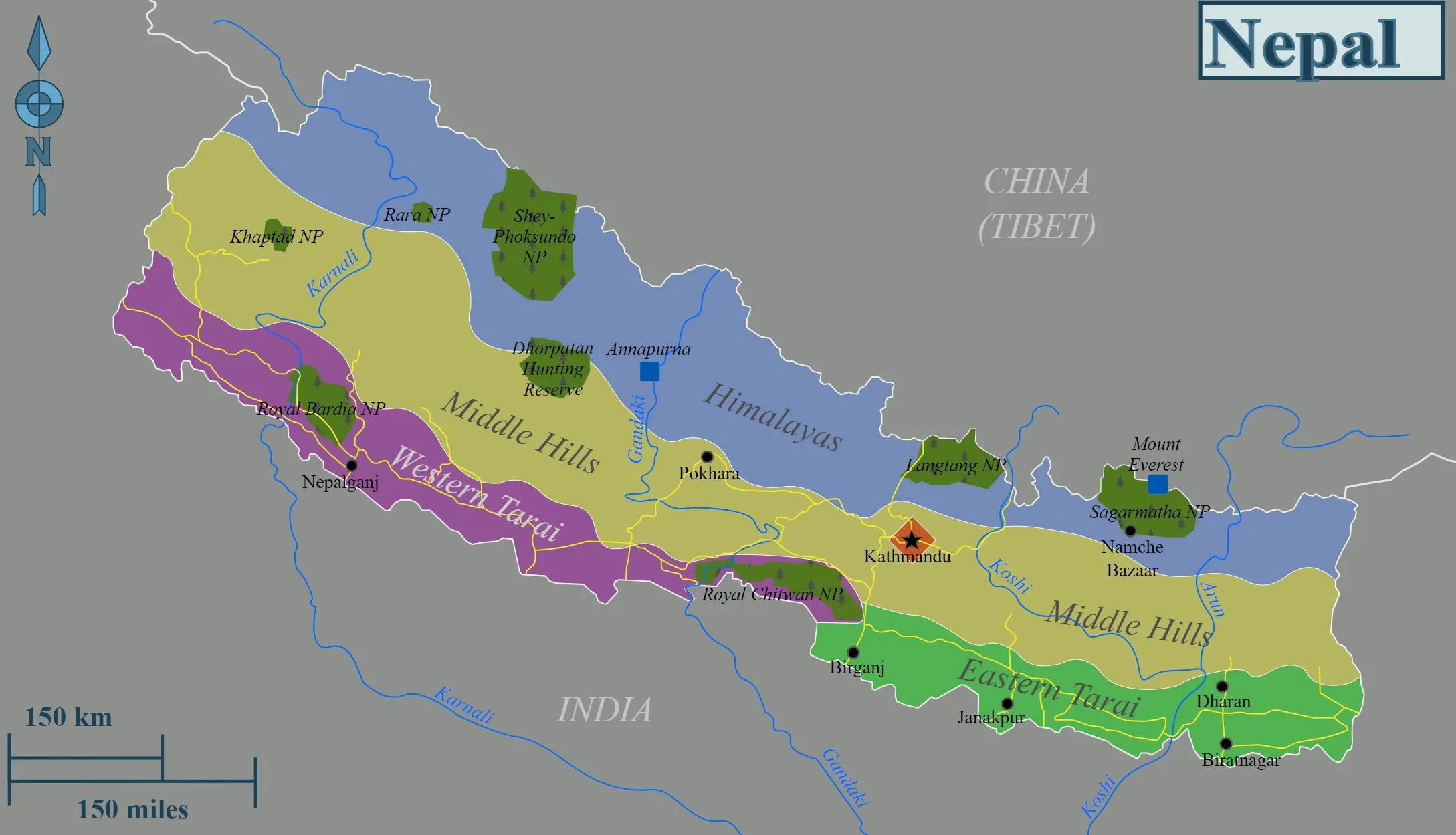
How to Choose the Right Map for Remote Trails?
For choosing the right map, you need to first understand what kind of terrain or destination you plan to trek on. For trekkers and hikers, a topographic map is the best choice.
These maps represent the route, elevation, and shape of the region using contour lines and symbols, giving you a three-dimensional view of the trail.
Scales such as 1:25,000 or 1:50,000 are ideal for easy navigation. This allows you to identify features like streams, cliffs, and forest cover as accurately and conveniently as possible.
Symbols and legends are also equally important on the map. They represent popular landmarks, rivers, teahouses, and emergency shelters, too.
Before starting any treks in Nepal, we recommend you get familiar with all the elements of the map, so that you’re not decoding them mid-journey.
While digital maps from apps like Google Maps Offline or maps.me are great companions, they must not be fully relied upon.
So, do not forget to add a physical, waterproof map when you are exploring areas far from civilisation.
How to Use a Map and a Compass for Beginners?
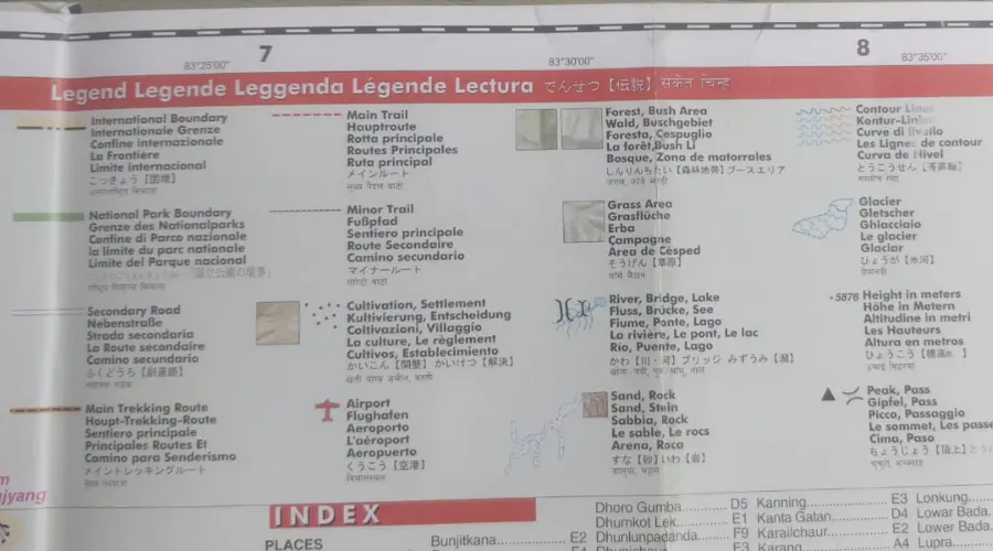
For better navigation, you need to have knowledge of how to use both the topographic map and a baseplate compass. A topographic map provides an overall view of the landscape. Meanwhile, the compass helps you find direction and maintain pace.
Even if there is no trail, if you know how to use these maps and compasses properly, you will always find a route.
The baseplate compass consists of a transparent base, a rotating bezel, and a magnetic needle. If you suspend the compass freely, the red end of the needle always points to Earth’s geographic north. Being able to read this, known as declination, lets you stay on course.
This declination can change with a change in geography. So, it is important that you look at the instructions on topographic maps. So, a topographic map and a compass go hand in hand. You need to be able to read these instructions as a beginner or a seasoned trekker.
As a beginner, it is normal for you to miss including a map in your packing list. In such a case, a compass alone can guide you by maintaining a consistent direction where you are headed.
How to Orient the Map?
Learning how to orient the map is one of the most useful and basic navigational skills. When read correctly, the map reflects the actual terrain around you.
To orient your map, place it on a flat surface and align it with the north-south grid lines using your compass. Make sure the compass’s north-south perfectly aligns with your map’s north-south. Once aligned, adjust for declination, and your map is now oriented.
Now you get the overview of the terrain and villages; landmarks begin to unfold in front of you. This process is particularly useful when trying to understand the topography of the route you are trekking on.
On the Everest Base Camp trek route, Google Maps fails above Namche Bazaar or Tengboche. The same is the condition during the Langtang Valley Trek or the Manaslu Circuit Trek route. In such cases, being able to orient the map really comes in handy.
Whether you’re figuring out where to go next or trying to identify nearby peaks and valleys, this technique helps you decide what it is.

How to Use a Compass to Find Direction?
As already mentioned, it is not just about orienting the map but about navigating through unknown land, from one village to another.
To use a compass to find direction, first place your compass on your map, with one edge pointing to your current location and another to your desired destination. Now rotate the bezel until it aligns with the map’s north.
Once it’s done, hold the compass in front of you and rotate your body until the magnetic needle aligns with the geographical north. The direction-of-travel arrow will now point toward your target.
This technique is especially useful in foggy conditions, nighttime or early morning navigation, or in terrains with similar orientation in all directions. With proper knowledge of how to use a compass, you can find directions during any condition without relying on trail markers or modern technology.
Finding Your Location in the Wilderness
Sometimes, the biggest challenge on the trek isn’t the altitude or knowing where to go; it’s not being able to find where you are. Especially if you are a solo trekker, this sort of problem is common.
Most of the trek routes in Nepal, especially at higher elevations, are areas where GPS doesn’t work. During such wild landscapes, having basic knowledge of how to use a map and a compass can help you know your location and find your way out.
Under such conditions, being able to use the triangulation method is quite handy. You identify two or three visible landmarks, might it be mountain or river bends, then you can take compass bearings on each of them and draw lines on your map to locate your position.
The point where they intersect is your approximate current location. When used with proper knowledge of elevation from contour lines, triangulation becomes a powerful method of self-location.
Even if you can’t find multiple landmarks, you can just match one known point with a nearby feature on the map and make an educated decision. From there, once you find other landmarks, reorient your map.
Important Things to Remember
Before heading out on your adventure, especially in the Himalayas and the remote, rocky terrains of Nepal, make sure you’re equipped with the right tools and knowledge.
Always bring a printed map and a compass, even if you have downloaded offline digital maps. Make a habit of checking the latest declination values where you are planning to hike.
Likewise, study the map beforehand and mark important locations, monasteries, water sources, lunch stops, teahouses, routes, viewpoints, etc.
Final Thoughts: Why Navigation Still Matters
The ability to navigate without any modern technology is one of the best skills you can learn. Knowing how to orient the map, use a compass, and get an overview of the terrain lets you walk carefree. It gives you freedom, confidence, and peace of mind.
These are long-practised navigational techniques that had guided thousands of explorers long before smartphones existed. Even when the signal dies or the battery dries, these topographic maps and backplate compass prevail.
So, the next time you plan your Himalayan adventure in some of the most beautiful, pristine and remote places, don’t forget to carry these essential tools.
Nepal Trekking Routes

related post
Want to know more?
Speak to an Expert


Sandip Dhungana
Nepal 🇳🇵
Whatsapp: +977-9823636377
Author
Samyog is a travel enthusiast and a content writer at Himalayan Masters. He likes to learn from experience. He likes learning and writing about different interesting topics and cultural aspects.


Leave Your Comment