




Trail Marker During Nepal Trek: Meaning and Importance
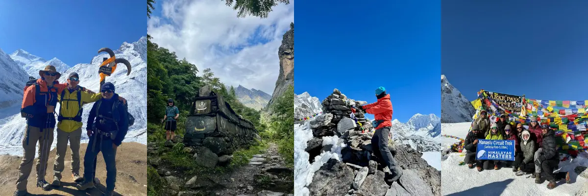
Trekking in Nepal isn’t just about following the trail marker, but about trusting the mountains to guide you. Still, in the wilds of the Himalayas, the routes can be unpredictable and sometimes confusing. One moment you’re walking on a clear path, with some of the most stunning views, and the next it disappears into a rocky slope, a dense forest, or a cloudy trail.
That’s when these trail markers prove to be a lifesaver. These small yet powerful signs, painted blazes, cairns, prayer flags, and hand-carved boards, become your silent guides.
They help you navigate the ever-changing terrain with confidence. Whether you’re walking on popular routes like Everest Base Camp or a remote Manaslu Circuit, these subtle signs ensure you stay on the right path.
Understanding how to read them not only ensures safety but drastically improves your entire trekking experience. These markers bind local knowledge, safety, and culture together in harsh Himalayan routes.
Learn how to read painted blazes and cairns, what prayer flags and mani walls signify, and what official signboards differ from local waymarks.

What are Trail Markers?
Trail Marker, also called blaze, waymark, or waypoint, is any physical sign placed to guide travellers along the route. They are there to show direction through forks, junctions, ridgelines, and difficult terrain.
These waypoints also help you avoid cliffs, landslides, river crossings, and dangerous glacier sections. They are there to ensure that you stay on the right path and are safe.
These signs are used globally; however, in Nepal, they aren’t just mundane symbols. Trail markers in Nepal are a blend of signage and centuries-old cultural markers, such as mani stones and prayer flags.
So, knowing the local language of markers makes all the difference.
Formal/Official and Informal Trails Marker in Nepal
In Nepal, trail markers are of two types.
- One is official markers installed by the government; blaze printed by Nepal Tourism Board and Annapurna Communities (NATT), distance boards, and official arrows.
- Another one is the informal cairns, prayer flags, stone mani walls, chalk arrows, ribbons, or handwritten wood signs made by locals or teahouses.

Why Trail Markers Matter in Nepal’s Trekking Routes
Nepal has stunning but demanding terrain. Adorned with breathtaking mountain views, lush rhododendron forests, roaring rivers, deepest gorges, and highest mountain passes, Nepal has diverse landscapes.
A single valley can include dense forest, rockfall zones, washed-out paths, snow-covered fields, and narrow cliff-side walkways. Along such a challenging route, a trail marker warns trekkers so they don’t miss a step or a view.
Even on a known route, the terrain could shift due to seasonal landslides or flooding. That’s where this waymark becomes a superhero. They help you:
Vast and Remote Mountain Terrain
The Himalayas are enormous and sparsely populated at high altitudes. Main trail branches off to yak pastures, shortcuts to the village, or to nowhere. Without markers, it is easy to drift off the trail and get dangerously off-route.
Weather Unpredictability
Fog, snowfall, landslides, and heavy rain can cover tracks within minutes. Painted blazes and cairns become essential when the visible trail disappears.
Safety, Accuracy, and Time Management
Trail markers help maintain trekking schedules, especially on routes where afternoon winds or snowfall can make passes risky.
Preventing Altitude-Related or Navigation Emergencies
Losing your way at altitude is dangerous. Fatigue, AMS symptoms, or cold exposure become more severe when you spend extra hours trying to relocate the route.
Rescue Reference Point
Provide reference points for rescues; a named signboard or a prominent cairn can be given to rescue teams.
Improve psychological comfort
Seeing reliable markers gives trekkers confidence to relax and enjoy the landscape instead of constantly second-guessing the route.

Types of Trail Markers You’ll See in Nepal
Here are some of the types of trail markers you’re likely to see in the Nepal trekking routes.
Painted Trail Marks (Blazes)
These are the most standardised markers in Nepal. You are likely to see these blazes on rocks and large boulders, tree trunks, retaining walls, and near sacred places (though never painted on sacred structures).
Painted blazes use colour codes to indicate directions and junctions. Common colours include:
- Blue and White: Common on NATT trains in the Annapurna region.
- Red and White: Small painted squares or arrows often marking major trekking routes
- Yellow: Used on less formal or local trails.
Painted trail marks are especially useful when multiple trails split or when the path goes over rocky terrain where footprints aren’t visible.

Cairns (Stacks of Stones)
Perhaps the oldest and most reliable Himalayan trail guides, Cairns are a pile of stones. They are mainly used above the tree line, on moraines, across windy high passes, and in some snowy zones where paint is invisible.
Crains are usually made by trekkers and guides. They are often decorated with prayer flags or mani stones, adding cultural value to these markers. So, treat them with respect and avoid toppling or rearranging them unless adding to maintain the route.

Prayer Flags and Mani Stones
Deeply connected to Tibetan culture, prayer flags and mani walls are useful landmarks, further enhancing the beauty of the trail.
Prayer flags include 5 different colored flags (blue, white, red, green, and yellow). It is commonly used for marking passes, ridgelines, stupas, or sacred crossroads. They’re not directional signs in the Western sense, but they do indicate important locations, often placed above a path to show the high point or sanctuary ahead.
Likewise, mani stones and walls (inscribed stones) also often mark trails and sacred places. Treat these markers with cultural sensitivity, don’t walk over mani walls, and avoid disturbing flags.
Signboards and Direction Panels
These signboards and directions panels are usually found around teahouses and lower-altitude routes. They are usually printed on wooden or metal boards with place names, distances, and altitude, installed by the government, NGOs, or local trekking communities.
Additionally, they are also used to indicate estimated walking time, warnings, and directions to side trips. They are extremely useful when planning and reporting your location during an emergency.
Note: Government signage is more standardised, while community signs may be hand-painted but are usually accurate for local paths.

Temporary Markers
Markers like ribbons, chalk arrows, or biodegradable trail tape are used for events, local festivals, construction work, trekking season rerouting, or shepherds’ paths.
These are temporary markings commonly found along trekking trails in Nepal. They’re useful but short-lived; don’t rely on them for long-distance navigation.
Importance of Trail Markers for a Safe Himalayan Trek
Here is the importance of a trail marker for a safe Himalayan trek.
Preventing Wrong Turns
A clear trail marker at a junction prevents from making a simple mistake, such as taking a wrong turn or an accidental descent. Follow painted blazes or cairns, or trek with an experienced guide for a safer trekking experience.
Avoiding Risk Zones
Markers help you identify safe lines and avoid risky zones. They are usually placed around landslide-prone sections, moraine crossings, wildlife trails, avalanche risk zones, or steep cliff routes used by locals but dangerous for trekkers.
Saving Time and Energy
Following the correct trail means you conserve energy and maintain your acclimatisation schedule. Markers that show distance or altitude are especially helpful for pacing.
Supporting Emergency Rescue
Named signboards, well-known cairns, and GPS coordinates from official markers help in locating you faster and for a quick rescue.
Confidence and Peace of Mind
Knowing where you are and how far you have to go offers peace of mind, especially when trekking solo or in low visibility.
Enjoying Nature Without Worry
Good navigation frees your mind to enjoy scenery, photography, and cultural interactions.

Combining Trail Markers with Modern Tools
The best navigation technique is combining traditional markers with modern tools.
- Map and Compass: Basic skills to read a map and compass, verify markers, and avoid following false trails.
- GPS and Offline Maps: Load GPX tracks or offline maps (e.g., Maps.me, Gaia GPS) before you go. GPS is invaluable when markers are missing, but don’t rely on it as batteries fail in cold conditions.
- Altimeter Watch: Useful to cross-check elevation when markers are sparse or absent on ridgelines.
Common Mistakes Trekkers Make with Trail Markers
Here are some common mistakes trekkers make with trail markers during the trek.
- Blindly following animal/porter routes: Yak and porter paths often lead to grazing fields or load-resting areas, diverging from the safest and official trail. In such cases, check for painted marks or cairns that indicate the main walking trail.
- Ignoring markers in bad weather: When visibility is low, especially during snow and monsoon, some trekkers assume they’ll find the trail later. Instead, slow down, consult the map/compass, and if unsure, backtrack to the last confirmed marker.
- Toppling or moving cairns: Sometimes done accidentally when scrambling, but moving a cairn can mislead others. Leave it as it is, or only add small stones to a cairn if you’re maintaining the route.
- Assuming One Marker Means You’re on the Main Route: Sometimes locals draw marks for their convenience or leading to a village shortcut, which might be confusing or dangerous for trekkers.
What to Do if Trail Markers Are Missing
If there is no trail marker or you missed some, firstly, do not panic and take haphazard measures. Here are other things you can do.
- Stop and assess: Don’t run ahead, hoping to “find” the route. Look back for the last marker.
- Backtrack to the last confirmed marker and try alternate junctions.
- Reassess with Map, Compass, or GPS to check distance, elevation, and direction.
- Look for natural reference points like ridges, rivers, stupas, or valleys for clues.
- Ask locals or other trekkers; even learning minimal Nepali phrases is useful.
- Contact your guide, agency, or local emergency services for help. Provide your last-known location, direction, and estimated elevation.
- Trekking with an experienced guide and registering at every checkpoint along the trek trail.

Expert Tips from Nepali Trekking Guides
Follow these expert tips for a memorable trek in Nepal.
- Treat the Trail Marker as your silent guide, especially on high passes.
- Check markers every 5-10 minutes, even on obvious routes.
- Never rush in unclear sections; slow trekking is safe trekking.
- During winter, rely more on cairns and tall signboards than on painted blazes.
- Always ask locals about trail conditions, especially after monsoon or landslides.
- Marks in Annapurna may differ from those in Manaslu or the Everest region. Learn about them beforehand.
- If trekking independently, make sure to get a comprehensive travel insurance that covers helicopter evacuation.

You Might Also Want to Know
Do I need a guide if the trail is well-marked?
Markers help, but guides are well-known about the weather patterns, detours, and safety zones. For winter, monsoon, or remote treks, guides are strongly recommended.
Are trail markers reliable in Nepal?
On major routes, yes, but not always in remote or newly rerouted areas. Always cross-check with maps.
What colour markers are most common?
Red/white and blue/white (NATT) are widely used in Annapurna. The Everest region has more signboards and fewer painted blazes.
Are markers visible in winter?
Snow can hide painted markers and small cairns. Look for tall cairns, prayer flags, and ridgeline markers in winter.

Final Thoughts
A Trail Marker may look small, but it plays a huge role in Nepal’s trekking routes. These waypoints help you navigate, reflect on local culture, and ensure your safety. It is usually painted on trees, rocks, wooden or metal boards, or simple yet spiritual prayer flags and mani stones.
Respect the markers along the route and do not tamper with them. They are there to guide us through challenging, confusing terrain high in the Himalayas.
Reading them carefully, combining them with modern GPS tools, or using local guides when in doubt, is wise. With a little knowledge and respect, markers can elevate your trekking experience from a good to an excellent journey of a lifetime.
Loading...
related post


Author

Samyog Shrestha is a travel enthusiast and an excellent content writer at Himalayan Masters, the face behind the amazing content who likes to learn from experience.


Leave Your Comment