




Gaurishankar Conservation Area: The Ultimate Travel Guide
Located at elevations ranging from 968 m (3,175 ft) to 7,181 m (23,560 ft) above sea level, the Gaurishankar Conservation Area (GCA) lies between two iconic regions: Sagarmatha National Park to the east and Langtang National Park to the west. To protect its unique natural and cultural resources, the Government of Nepal declared the area a conservation area in 2010.
The area has beautiful mountain scenery and untamed wilderness. Wildlife and plants flourish here in rich biodiversity. Unlike other travel destinations, Gaurishankar’s unique topography and religious identity give the area a distinct character and a relatively less commercialized atmosphere.

From moderate valleys to high-altitude adventure, Gaurishankar Conservation Area offers a variety of trekking routes. The four rewarding trekking routes are Rolwaling Valley Trek, Tsho Rolpa Lake Trek, Pikey Peak Trek, and Everest Base Camp Trek via Jiri (the old classic route).
The Conservation Area is home to many endangered species. It is also an important water catchment area with major glaciers. This is why it was declared a Conservation Area by the Government of Nepal.
Where is the Gaurishankar Conservation Area Located?
The Gaurishankar Conservation Area is located in the north-central Himalayas of Nepal. Tibet borders the conservation area to the north. It covers parts of Ramechhap, Dolakha, and Sidhupalchowk districts.
When was GCA Established, and Who Manages It?
The Gaurishankar Conservation Area (GCA) was established on January 11, 2010. The Government of Nepal entrusted the management of the conservation to the National Trust for Nature Conservation (NTNC) on July 19, 2010.
This helps to preserve the region while actively supporting the local communities. It focuses on biodiversity protection, community development, and sustainable livelihoods.
Connection with Mt.Gaurishankar and its Cultural Significance
Gaurishankar mountain (Himalaya), one of Nepal’s culturally and religiously significant Himalayan peaks, features two summits in the Rolwaling Himal Range. The locals call the higher Northern peak Shankar 7,134 m (23,405 ft), and the slightly lower Southern peak Gauri at 7,010 m (22,998 ft). It is located within the border of Nepal (Dolakha district) and Tibet (China).
The mountain is more than a geographical feature. It also holds cultural significance. According to the local tradition, Gaurishankar represents the unbreakable union of Lord Shiva and Goddess Parvati.
Gaurishankar has great religious significance, and people’s attitudes toward and respect for the mountain have been shaped by its sacred status. Rather than viewing the mountain as merely a climbing destination, trekkers typically enjoy it from nearby routes.
How is the Connection between People and Culture Within the Conservation Area
The culture in Gaurishankar Conservation Area is closely intertwined with Tibetan Buddhism and Hinduism. The conservation area has diverse communities. Sherpa, Tamang, Thami, Jirel, Newar, Brahmin, and Chhetri are the inhabitants in this region.
While many Tibetan Buddhists reside high in the mountains and northern valleys close to the Tibetan border, the lower elevations are usually inhabited by people from Hindu communities.
Therefore, Buddhist culture influences high-altitude settlement areas. The influence is reflected in the architecture of the houses, prayer flags, chortens, and ancient monasteries, mirroring the strong Tibetan cultural ties.
Similarly, many religious sites, most significantly the revered Kalinchowk Bhagwati temple in Dolakha district, draw thousands of religious pilgrims every year, especially during major religious festivals.
Life and Survival around the Conservation Area
In the upper region, the economy is highly adapted to extreme conditions. Many local residents, particularly from Sherpa communities, work as international high-altitude mountain guides, expedition cooks, and camp staff for expeditions as their major source of income.
Seasonal herding, raising yaks, naks (female yaks), and chauri (yak-cow hybrids) are also sources of income for other families. Locals produce and market dairy goods to Kathmandu’s dairy markets and lower valleys, including butter, ghee, and Yak cheese called Churpi.
At higher elevations, farmers mainly grow cold-resistant crops, primarily potatoes and barley, due to the climate’s unsuitability for crop cultivation.

As for the mid-hill and lowland livelihood, most locals survive on agriculture. They cultivate crops like maize, millet, wheat, and paddy. Some households keep a small number of cattle, buffaloes, and goats for milk, meat, and to plow the terraced land. The development of trekking routes and growing tourism has helped the locals to run small teahouses, homestays, and small lodges.
Despite the lack of facilities, basic schools and public infrastructure exist within the Gaurishankar Conservation Area. Most families often send their older children to boarding school in lower regions or Kathmandu.
There is a state-run health post that provides basic first aid, immunization, and prenatal care. However, in case of emergency and complex medical cases, residents travel down to Charikot or Dhulikhel Hospital.
Festivals and Celebrations
Local communities celebrate several major festivals in the Gaurishankar region. These include Dumji, Lhosar, Buddha Jayanti, Kalinchowk Jatra, and Janai Purnima.
Dumji Festival (Sherpa)
Monks perform sacred, masked ritual dances (Cham) to drive off evil spirits. Families gather to share happiness, offering butter tea, local rice wine (Chhyang), and blessing the community.
Lhosar (Sherpa and Tamang)
The respective communities celebrate Sonam Lhosar and Gyalpo Lhosar, according to their cultural calendars. Sonam Lhosar is closely associated with Tamang communities, while Tibetan communities, including Sherpas, celebrate Gyalpo Lhosar.
Both communities celebrate the Lunar New Year by going to monasteries, offering prayers, raising new prayer flags on rooftops, and organizing family gatherings and community events.
Buddha Jayanti
People worldwide observe the birth, enlightenment, and passing of Lord Buddha. Locals visit monasteries to chant mantras, offer prayers, hoist new prayer flags, and light butter lamps in local Gumbas.
Kalinchowk Jatra and Janai Purnima
The Kalinchowk Bhagawati Shrine attracts many pilgrims. On the full moon festival of Janai Purnima (usually in August), thousands of Hindu pilgrims and Tamang ∕ Thami shamans trek to the summit.
The shamans beat traditional drums (Dhyangro), performing the rituals to honor the goddess and the mountain spirit.
Wildlife and Flora along the Gaurishankar Conservation Area
With elevations ranging from subtropical valleys at 968 meters (3,176 feet) to snowy peaks at 7,100 meters (23,294 feet), the Gaurishankar Conservation Area has an exceptional variety of biodiversity.
Fauna
The data provided by the NTNC shows that the area provides habitat for a high diversity of mammals, birds, reptiles, amphibians, and plant species. One NTNC mammal assessment recorded 77 species of mammals. Researchers confirmed only 32 through direct observation.
Mammals: It is a safe haven for rare high-altitude predators like the Himalayan wolf, snow leopard, Asiatic black bear, and Asian golden cat. It serves as a major habitat for the endangered red panda.
The area supports species such as Himalayan tahr, Himalayan musk deer, Himalayan serow, Himalayan goral, and Assamese macaque.
Reptiles and Amphibians: The area has 14 species of snakes, 10 species of amphibians, and 8 types of lizards.
Birds: An earlier NTNC report recorded 252 species of birds, including high-elevation pheasants like Himalayan monal, Blood pheasant, and various eagles and vultures.
Flora
GCA is also rich in medicinal plants and endemic species, which are traditionally used by local communities to sustain themselves, access healthcare, and preserve ancestral knowledge. One of the conservation area’s key objectives is protecting this biodiversity, thus harmonizing ecological preservation with long-term benefits.
The natural environment of Gaurishankar Conservation Area is immensely diverse. Forest and bushes cover 44.5%, cultivated land is 8.8%, grasslands are 8.6%, and glaciers are 2.77%. Barren land and other areas cover the rest of the total land.
Lower valleys have dense forests of oak, Pinus wallichiana (blue pine), and various rhododendron species, including Nepal’s national flower, Rhododendron arboreum, which create lush landscapes in spring and summer.
As elevation increases, we see more alpine meadows, rocky mountains, glaciers, Himalayan juniper, and snow-covered peaks.
Medicinal herbs like Panchaunle (fingered orchid), Jatamansi, Padamchal, Kutki, and Chiraito are traditional plants that grow in the conservation area. Other local resources like Allo (himalayan nettle), Argeli, Lokta, and various lichens are used for local trade and medicinal purposes.
Gaurishankar Conservation Area Weather and Temperature
Many travelers consider Spring and Autumn the best times to visit the Gaurishankar Conservation Area and other Himalayan regions.
Spring (March-May)
This season is most recognized for its biodiversity, with the whole landscape blooming in rhododendron forests. The temperature is mild, making it suitable for travelers to trek with clear mountain views.
While temperatures at higher elevations might drop below freezing, especially at night, lower valleys stay comparatively mild throughout the spring.
Autumn (September-November)
Autumn is generally considered one of the most favorable seasons to trek, as the monsoon rain leaves the atmosphere incredibly fresh and clean, offering excellent visibility of the mountain range and landscape.
There is a significant difference between temperatures at the lower and higher elevations. The lower valley remains warm and humid, while nights at high altitude become sub-zero and frosty.
Monsoon (June-August)
The monsoon season can be quite risky to trek because of heavy rainfall, risk of landslides, slippery pathways, and leeches around the area. Trekkers are recommended to carry waterproof boots, rain jackets, salt pouches, and leech-repelling creams.

Trekking is possible in the lower areas during the monsoon. However, trekkers should avoid the upper areas. Snow can make trekking difficult and unsafe.
Winter (December-February)
Trekking in the Gaurishankar region during winter is challenging due to severe cold, heavy snowfall, and icy winds. Although it offers clear blue skies and quiet trails, trekking can be quite risky as the trails are covered with snow.
Trekking Routes from Gaurishankar Conservation Area
Gaurishankar Conservation Area offers rewarding and major trekking destinations of Nepal with legendary routes such as Pikey Peak, Rolwaling Valley Trek, Tsho Rolpa Lake Trek, and Everest Base Camp via Jiri. Here’s a closer look at each of the four routes introduced above.
Pikey Peak trek
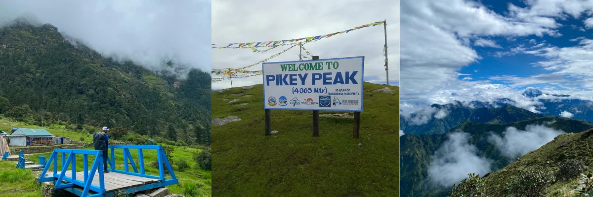
Pikey Peak lies in the Solukhumbu district at an elevation of about 4,065 meters (13,336 feet). Many trekkers consider it one of the best viewpoints in the Everest region. You can reach it from the wider Gaurishankar-Jiri region, making it a great spot for travelers exploring the nearby trekking paths.

Before reaching the summit of Pikey Peak, the journey usually starts in Kathmandu with a drive to Jiri or Shivalaya, passing through villages like Bhandara, Sete, Jasmane Bhanjyang, and Pikey Peak Base Camp. You begin trekking in Dolakha/Ramechhap, passing through the Gaurishankar Conservation Area before climbing up to the Pikey Peak.
Tsho Rolpa Lake Trek
Located at an elevation of approximately 4,580 m (15,026 ft) in the Rolwaling Valley of the Gaurishankar Rural Municipality in the Dolakha district, Tsho Rolpa Lake is among the largest glacial lakes in the country and a major highlight of the Gaurishankar Conservation Area.
The journey starts in Kathmandu and travels through different places like Charikot, Singati, Chhetchhet, Simi Gaun, Beding, Na village, and Tsho Rolpa Glacial Lake. Glaciers and snow-covered peaks surround the lake, creating high-altitude landscapes.
The road journey reaches the trailhead at Chhetchhet, followed by several days of trekking through the Rolwaling Valley to Tsho Rolpa.
Rolwaling Valley Trek
When trekking in the Rolwaling region, you can either prefer doing a standalone Rolwaling Trek, or a trek combined with Tsho Rolpa Lake Trek.
The Rolwaling Valley is a deep mountain valley located inside the northern part of Gaurishankar Conservation Area. The trek commences from Chhetchhet (Dolakha district) and then passes through Sherpa villages (Beding and Na), rural landscapes, vegetated hillsides, and suspension bridges before stepping into the wild and remote Rolwaling Valley.
Everest Base Camp Trek via Jiri
The initial altitude of Jiri is 1,905 m (6,250 ft) and then continues to 2,840 m (9,318 ft) to Lukla. The trail stretches around 95 km (59 miles) and takes around 6-8 days, eventually connecting with the standard Everest Base Camp Trek route at Chheplung.
The Jiri trail begins at Shivalya, which sits inside the southern part of the Gaurishankar Conservation Area. After trekking past the conservation area you cross the Lamjura La Pass, which is the physical exit out of the conservation area.
After exiting the Gaurishankar Conservation Area, the trail continues through lower Solukhumbu and merges with the main Everest Base Camp.
Gaurishankar Conservation Area as a Hydrological Hub
The Gaurishankar Conservation Area is vital for water resources due to its glaciers, glacial lakes, and river systems. These glaciers, lakes, and rivers provide important water resources for Himalayan river basins and local communities.
Tama Koshi River:
The Tama Koshi River Basin spans from 465 m (1,526 ft) above sea level where it joins the Sun Koshi River, to enormous peaks like Gauri Shankar Himal, which are more than 7,000 m (23,000 ft) within its catchment.
The vast river network shapes the conservation area’s deep, striking western valleys. It is a major snow-fed Himalayan river in Nepal and is important for hydropower development in Nepal.
Rolwaling Chu:
The Rolwaling Chu drains the high-altitude Rolwaling Valley, transporting meltwater from glaciers and Tsho Rolpa toward the lower valley before joining the Tamakoshi River system.
The Bhotekoshi River:
The elevation of the Bhotekoshi River varies as it drops from the Tibetan Plateau down into Nepal through a steep mountain valley.
It is a significant tributary of the Koshi River system that borders the western side and is well-known throughout the world for whitewater rafting. The river is popular for extreme kayaking, canyoning, and high-altitude bungee jumping.
How to Reach Gaurishankar Conservation Area?
From Kathmandu, you can go to the Gaurishankar Conservation Area by taking a shared private vehicle or local bus to local trailheads such as Singati Bazaar, Charikot, or Jiri. Travel time and fares can vary. Road conditions, traffic, and the season can affect both.
To Singati / Chhetchhet: Rolwaling Valley Gateway
You can take a local bus or hire a private jeep from Kathmandu to Singati Bazaar. Singati Bazaar is located in Dolakha district. From there, take a local vehicle or walk for approximately 2 hours to reach Chhetchhet. It is a major trekking entry point.
The route from Kathmandu to Singati Bazaar is roughly 155-183 km (96-114 miles). It usually takes 5-6 hours by jeep or car, and around 7-8 hours by public bus, due to regular stops and road conditions.
To Dolakha Headquarters (Charikot)
The driving distance from Kathmandu to Charikot is roughly 132 km (82 miles). The journey takes around 4 to 5 hours by jeep or car and around 6 to 7 hours by a public bus. The public bus usually leaves from Gongabu Bus Park or Ratnapark bus area in Kathmandu.
To Everest (Jiri Approach)
The distance from Kathmandu to Jiri is approximately 182 km (113 miles) and takes about 5 to 6 hours by a private jeep and about 7 to 9 hours by a public bus.
The public bus fare can cost around NPR 1000, and as for the private jeep, it costs around NPR 18,000 to 22,000. A private shared jeep is more flexible and comfortable despite the vast difference in cost. It is also cost-efficient, as the cost is divided among the number of people traveling.
There are no direct commercial domestic flights to the Gaurishankar Conservation Area. The harsh landscape inside the park does not have a commercial airport. However, there are other aviation operations considering your budget and itinerary. For those who prefer to fly rather than drive, here are the air options into the region:
Helicopter Charters (Direct Option)
Helicopter charter flights are the only air travel option to the Gaurishankar Conservation Area for travelers seeking a faster and more direct option. Direct charter flights to particular park locations are operated by private helicopter firms from Tribhuvan International Airport (TIA). Popular drop-off locations include picturesque locations like Kalinchowk Bhagwati Temple or high-altitude communities in the Rolwaling Valley.
You can also take a flight from Kathmandu to a nearby domestic airport and take a bus or jeep to the main gateways.
Manthali Airport (Ramechhap): It is geographically the closest airfield to the southern part of the Conservation Area.
Lukla Airport: During peak trekking seasons, Lukla flights may operate from Ramechhap/Manthali Airport rather than Kathmandu. It depends on airline schedules and airport operating arrangements.
This option works well for travelers embarking on a Jiri-to-Lukla trek or a route crossing the Tashi Labsta Pass into the Everest region.
How are the living conditions on the trail?
The tea house conditions in the Gaurishankar region (especially along the Rolwaling Valley or Tsho Rolpa Lake route) are very traditional and basic.
Sleeping Accommodation: Lodges have simple bedding with limited insulation. Nighttime temperature can drop below freezing, so a warm sleeping bag is recommended.
Dining and Food: The main dining area is the only heated space in the tea house, warmed by traditional stoves or fireplaces. Food includes common Nepali food like Dal Bhat, momo, noodles, soup, fried potatoes, and hot teas.

Bathroom and Showers: Attached bathrooms may become unavailable beyond the lower villages. Toilets are usually squat-style; some stand outside the house. Lower villages may offer hot water for an additional fee. As you move higher, hot water is rare.
Wi-Fi and Mobile Network: In higher trekking areas like the Rolwaling Valley or Lapche, Trekkers may have very limited or no Wi-Fi and mobile connectivity. Mobile signals may occasionally work in lower villages, and some lodges may offer basic, fee-based Wi-Fi.
Which permits do I need for the Gaurishankar Conservation Area?
Permit requirements depend on the specific trekking route and the administrative areas it crosses. Trekkers should confirm the latest requirements before departure.
Trekkers must obtain a Restricted Area Permit along with the Gaurishankar Conservation Area Permit if you are trekking through the higher sections of the Rolwaling Valley Trek, such as Na Village.
Khumbu Pasang Lhamu Rural Municipality Entrance Permit and Sagarmatha National Park Permit are mandatory for the Jiri to Lukla (Everest Region) Trek.
The permit requirements for Gaurishankar Conservation Area vary according to the trekking route and the areas included in the itinerary. Trekkers should obtain all the necessary permits before entering the conservation area and keep their permits and identification documents with them throughout the trek.
Routes that enter restricted or controlled areas may require additional permits. Trekkers taking the Jiri-Lukla route to Everest Base Camp may also require permits for the Khumbu region and Sagarmatha National Park.
Tips!
Trekkers should check with the latest government authorities in Nepal, as permit regulations and fees can change. Before starting on their journey, they should contact the Gaurishankar Conservation Area authorities or the Tourism Board.
Things to Remember:
- A valid passport, identification document, and the required permits
- Check route-specific permit requirements before traveling.
- Some restricted areas may have additional entry requirements or guide regulations.
- Keep the permits safely throughout the trek, as they may be checked at designated checkpoints.
- Always confirm the latest permit fees and regulations before departure.
Why is Gaurishankar a best destination for trekkers?
Unlike many other trekking destinations, Gaurishankar Conservation Area is not heavily trafficked and receives only a small number of tourists, making the trekkers’ experience a quiet, undisturbed wilderness.
The area is rich in culture, as it is home to local communities like Sherpa, Tamang, and Thami that offer genuine cultural immersion rather than commercialized hospitality.
The raw thrill of trekking in Gaurishankar Conservation Area is the fact that this place is an escape from the busy, hustling modern cities and packed tourist areas.
For more information about the Gaurishankar Conservation Area or its lesser-known trekking routes, Himalayan Masters can help you explore the region and tailor an itinerary to your time, interests, and trekking preferences.
FAQs
Who manages the Gaurishankar Conservation Area?
What are the trail conditions of GCA?
How to keep devices charged and stay connected during GCA Tour?
Who provides emergency support?
Is travel insurance recommended for GCA Trek?
Are there any exclusions or conditions?
What should I pack for GCA Trek?
Are snow leopards found in the Gaurishankar Conservation Area?
What are the major trekking routes in the Gaurishankar Conservation Area?
Is Gaurishankar suitable for beginner trekkers?
What ethnic communities live in the Gaurishankar Conservation Area?
Are trekking lodges available in the Gaurishankar Conservation Area?
Loading...
related post


Author

Panjum Tamang is a travel content writer with deep enthusiasm for destination research and cultural exploratioon developed from her current major Meteorology in university. She translates immersive travel experiences into pragmatic and actionable content.


Leave Your Comment