




Langtang River: The Main Glacial River of Langtang Valley
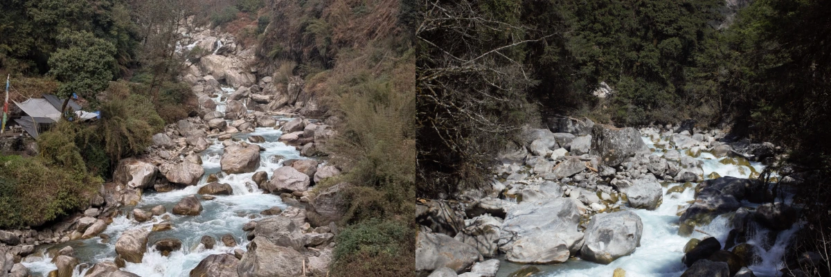
The Langtang River is one of Nepal’s major glacial rivers, flowing for around 60-70 km (37.28-43.5 mi) through the Langtang Valley in Rasuwa District.
The river begins at the Langtang Lirung Glacier and is fed by snow and ice melt from the surrounding high mountains. From its source in the upper Himalayas, it flows towards Syabrubesi through alpine meadows, mountain villages, and dense forests.
Unlike many rivers of Nepal that generally flow southward from the Himalayas, the Langtang Khola follows an east-to-west course through the valley before merging into the Bhote Koshi. From there, its water becomes part of the Trishuli and wider Narayani river system.
Along its course, the Langtang River passes through one of Nepal’s well-known Himalayan valleys, supporting the natural landscape and communities of the region.
Langtang River Quick Facts
The following are some of the main facts concerning the Langtang Khola, along its course from its glacial origin to where it runs through the Langtang Valley.
| Feature | Details |
| Local name | Langtang Khola |
| Location | Rasuwa District, Bagmati Province, inside Langtang National Park |
| Formation | Glaciers, snowmelt and moraines around Langshisa Kharka |
| Contributing Mountains | Langtang Lirung, Langtang Ri, Dorje Lakpa, Gangchenpo and Langshisa Ri |
| Flow direction |
East to West
|
| Estimated length |
Around 60-70 km (37.28-43.5 mi)
|
| Elevation range |
Above 4,000 m (13,123 ft) in the upper valley to around 1,500 m (4,921 ft) at Syabrubesi
|
| River connection | Langtang Khola → Bhote Koshi → Trishuli → Narayani → Ganga |
| Main trekking route | Langtang Valley Trek |
Where Is the Langtang River Located?
The Langtang River, locally known as the Langtang Khola, is located in Rasuwa District of Bagmati Province, central-northern Nepal. Much of its course runs through Langtang National Park and the Langtang Valley, close to Nepal’s northern border with Tibet.
The Langtang River lies roughly 32-60 km (20-37 miles) north of Kathmandu if measured in a straight line. By road, the journey to the Langtang River is considerably longer, at around 113-122 km (70-76 miles), depending on the destination.
The river forms an important part of the Langtang Valley landscape. The region is widely known as the “Valley of Glaciers” because of the numerous glaciers scattered across its high mountains.
The upper reaches of the river lie in the high Himalayan landscape, while its lower course flows through steep, forested valleys before reaching Syabrubesi. This elevation change gives the Langtang Valley River a close connection with both the alpine environment of the upper valley and the settlements farther down the valley.
The Origin and Journey of the Langtang River
The Langtang River does not originate from a single spring that can be pointed on a map. The Langtang Glacier is one of the major contributors to the river.
Its upper reaches are fed by numerous glaciers. Small streams collect meltwater from glaciers, permanent snow, and rocky moraines, which helps to increase the volume of the Langtang River.
The surrounding mountains play an important role in shaping the river’s origin. Langtang Lirung, the mountain where the Langtang Glacier sits, rises to around 7,234 m (23,734 ft). It is one of the dominant mountains of the upper valley that contributes to the river.
The wider Langtang region contains more than 70 glaciers of distinct sizes according to the NTB (Nepal Tourism Board). However, the exact number depends on the geographical area and classification used.
From the higher valley, the water gathers strength as it descends. It passes below Kyanjin Gompa, Langtang Village, Ghodatabela, Lama Hotel and Bamboo before reaching Syabrubesi.
At Syabrubesi, the Langtang Khola meets the Bhote Koshi. The combined water continues into the Trishuli system and eventually becomes part of the Narayani and Ganga basin.
Gosaikunda Lake is also part of the wider river system around this region, although it is not a source of the Langtang River. Water from Gosaikunda drains through a separate stream and eventually joins the Trishuli system farther downstream.
Mountains Contributing to the Langtang River
The river’s character is inseparable from the mountains around it.
Langtang Lirung is the dominant peak above the valley, rising to around 7,234 m (23,734 ft). Other major peaks include Langtang Ri, Dorje Lakpa, Gangchenpo and Langshisa Ri.
These mountains are not simply scenery behind the river. Their glaciers, snowfields and high-altitude terrain form part of the watershed that feeds it.
From higher ground, you can see how the river fits into the larger landscape: small channels coming down from the high mountains, joining together as they descend, then disappearing into the narrower valley below.
Langtang River Map and Route
The easiest way to understand the Langtang River is to follow it down from the high valley to Syabrubesi. It starts from the glacial streams near Langshisa Kharka and the upper Kyanjin area.

The river continues through the lower Langtang Valley before reaching Syabrubesi. Here, it joins the Bhote Koshi and eventually becomes part of the Trishuli and Narayani river systems.
Much of its route follows the classic Langtang trekking corridor. However, the trail moves away from the river in some sections.
How the Langtang Khola Changes with Landscape?
The Langtang Khola changes noticeably as it flows down the valley. Its surroundings shift from the wider lower valley around Syabrubesi to dense forests, open riverside sections, villages, and eventually the rocky alpine landscape above Langtang Village.
From Syabrubesi to Dovan, the valley is relatively wide. The Langtang River flows through the lower valley, with the trail following its course as it gradually moves deeper into the mountains.
Beyond Dovan, the trail enters denser forest and continues towards Rimche. Oak, rhododendron, and bamboo cover the slopes, and the river is not always visible from the trail. You can often hear it rushing below through the trees.
From Rimche, the trail climbs more steeply towards Lama Hotel. In several sections, the river runs below the trail, while the riverside becomes wilder and more open, with large rocks and steep slopes around the water.
As you continue from Lama Hotel towards Ghodatabela, the forest remains an important part of the landscape, but the valley gradually opens. Around Ghodatabela and further towards Langtang Village, the slopes feel wider, the trees become less dense, and the river has more room to move across its rocky bed.
Above Langtang Village, the scenery changes again. Forest gives way to pasture, moraine, and exposed mountain terrain as the trail continues.
By the time you reach Kyanjin Gompa, the river no longer appears as one continuous channel beside the trail. Instead, smaller streams and glacial channels run through the rocky landscape, carrying meltwater down from the surrounding mountains.
Why is Langtang River Important to the Langtang Valley Trek?
The Langtang Valley Trek and the Langtang Khola are closely connected. The river is like a natural guide for the trek, accompanying the trail for much of the journey towards Kyanjin Gompa.
The trek begins at Syabrubesi, where the trail crosses the Bhote Koshi before entering the Langtang Valley. From there, the route follows the Langtang Khola through Bamboo, Lama Hotel, Riverside, Ghodatabela, and Langtang Village before reaching Kyanjin Gompa.
The river is not right next to the path at every moment of the journey, but it is still present. Sometimes the trail runs close to the water, while in the forest the river can be heard rushing below the trees.
At Rimchephedi and around Ghodatabela, the suspension bridge takes trekkers directly over the river and its smaller channels.
As the trail climbs higher towards Langtang Village and Kyanjin, the river gradually becomes part of the broader mountain landscape rather than simply something beside the path.
Villages and Teahouses Along the Langtang Khola
Several of the main villages and teahouses on the Langtang Valley Trek are closely associated with the river.
| Place |
Elevation
|
Relationship with the river |
| Syabrubesi |
1,503 m (4,931 m)
|
Langtang Khola meets the Bhote Koshi |
| Bamboo |
Just under 2,000 m (6,562 ft)
|
Teahouses and settlements close to the river |
| Riverside |
About 2,760 m (9,055 ft)
|
Teahouses close to the river, with wider riverbank
|
| Lama Hotel |
2,470 m (8,104 ft)
|
River runs below the forested trail |
| Ghodatabela |
2,972 m (9,751 ft)
|
Open terrain with broader views |
| Langtang Village |
3,430 m (11,253 ft)
|
Settlement lies on the wider valley floor |
| Kyanjin Gompa |
3,870 m (12,697 ft)
|
Close to upper river channels and glacial sources |
The trek starts at Syabrubesi, where the Langtang Khola is a strong part of the landscape. The valley is relatively wide here, and the river flows through the lower section as the trail begins heading into the mountains.
From Domen, the valley narrows and becomes more forested. The trail continues along the Langtang Khola, with the river often flowing below the path through the trees.
At Bamboo, the river becomes particularly noticeable. The few teahouses that exist sit close to the water, and the water’s rushing sound can be heard very easily.
From Bamboo, the trail continues towards Lama Hotel through dense forest. The river is not always visible from the teahouses, but you can clearly hear it rushing below and through the valley.
The Riverside section brings the trail closest to the Langtang Khola. The river runs alongside the settlement and the trail, giving visitors the closest interaction with it.
Beyond Riverside and Lama Hotel, the valley opens as you approach Ghodatabela. The forest becomes less dense, and the Langtang Khola has more space to move through the wider valley.
Where Can You Get Closest to the Langtang River?
You do not need a separate excursion to see the river. Much of the main trekking route already follows it.
Still, some sections are particularly good if you want to experience the Langtang Khola rather than photograph it from a distance.
Syabrubesi to Dovan
The lower section between Syabrubesi and Dovan gives one of the first extended experiences with the river. The valley is still fairly narrow, and for most of the way you have the sound of running water with you.
Pahiro
Around Pahiro, the trail comes close to the river, and the surrounding gorge becomes more dramatic. This is also an area where the slope can be unstable, especially after rain, so it is not a place to stop casually for a long time.
Bamboo
Bamboo is one of the easiest places to notice how closely local settlements are connected to the river. Several teahouses are positioned near the water, and the river remains audible around the settlement.
Rimchephedi
After crossing the bridge above Bamboo, some sections offer a particularly close look at the narrower river channel. The water is concentrated between rocks, making it easier to see the force of the current.
Riverside to Chhunama
Riverside, by its name, is located right by the river. This place has easier access to the wider banks of the river. Camping and other activities can also be organized here. It can also be taken as a small beach. The section from Riverside to Chhunama gives you the closest view of the entire river during your journey.
Ghodatabela
Ghodatabela gives a more open view of the river as the forest starts to thin. It is also a useful point for appreciating how the river fits into the wider valley rather than seeing it only from inside the gorge.
Langshisa Kharka
If your itinerary extends towards Langshisa Kharka, you can travel much farther towards the upper area where the river’s glacial streams originate.
Riverside: One of the Closest Places to Experience the Langtang River
Riverside is one of the places where you can get particularly close to the Langtang Khola. This small settlement lies between Lama Hotel and Ghodatabela, with the trail running close to the river before continuing through the forest.

Unlike many sections where the river runs below the trail or is hidden among the trees, Riverside offers a better chance to see and feel the water up close. The wider basins allow trekkers to relax and even camp by the river.
The area has a few teahouses, so it is also a natural place to stop for a while and enjoy the river before continuing towards Ghoda Tabela.
For anyone who wants more than a quick glimpse of the Langtang River, Riverside is one of the better stops along this part of the trek.
How Does the Langtang River Look in Different Seasons?
The Langtang Khola changes considerably through the year. Temperature, snowmelt, rainfall, and sediment all affect how the river looks and sounds.
Langtang River in Spring: March to May
Spring brings increasing snow and glacier melt. The river can become stronger through the warmer part of the day, while the lower valley comes abounding in rhododendron flowers.
This is also one of the most popular periods for visiting the river because the weather is generally favorable and the mountain scenery becomes increasingly visible as conditions improve.
Langtang River in Monsoon: June to August
During the monsoon, the river carries considerably more water. Rainfall adds into the contribution from glacial and snowmelt, and the current can become swifter and more turbulent.

The surrounding hills also become more vulnerable to landslides. The lower Langtang trail has steep gradients and open sections where heavy rain can rapidly change its conditions. The river also bears the risk of flooding during the monsoon.
For anyone trekking during or around the monsoon, the condition of the trail matters just as much as the condition of the river.
Langtang River in Autumn: September to November
Autumn generally brings more settled conditions after the monsoon. Sediment levels often decrease, the sky becomes clearer, and the mountains are easier to see.
For photography, this is a particularly good time to appreciate the relationship among the river, the valley, and the adjacent peaks.
Langtang River in Winter: December to February
In winter, the Langtang River generally has less flow, while the upper valley becomes much colder. Snow is common at higher elevations, and ice can form around rocks and along the river. As temperatures drop, parts of the river become more subdued, especially in the upper valley.
The contrast is most noticeable around Kyanjin Gompa and in the higher reaches, where snow-covered slopes and frozen patches along the river lend the landscape a distinctly wintry character.
How to Reach the Langtang River?
For visitors, the practical starting point for reaching the Langtang River is Syabrubesi, which is also the trailhead to the Langtang Valley Trek.
The usual road journey from Kathmandu travels north through Trishuli Bazaar and Dhunche before reaching Syabrubesi. Depending on road conditions, traffic and the type of vehicle, the journey generally takes around 6-8 hours.
The Langtang Khola is encountered almost immediately as the trekking route begins climbing into the valley from Syabrubesi.
The Langtang River can also be reached through the Gosaikunda-Helambu trekking route. From Kathmandu, trekkers can approach via Sundarijal or Chisapani, continue towards Gosaikunda and Lauribina La, then make their way to the Langtang side via Thulo Syabru and surrounding trails.
Note:
Whichever route you take to explore the Langtang River, make sure you have the required Langtang trekking permits with you before you go.
Natural Disasters Along the Langtang River
The Langtang River runs through steep mountain terrain where heavy rainfall, landslides, floods, snow, and ice can all affect the surrounding valley.
The most devastating event in Langtang history occurred on April 25, 2015, when a massive earthquake triggered an avalanche of ice, snow, and rock above the valley. The resulting debris passed through Langtang Village and caused extensive loss of life.
The village was then reconstructed, and trekking slowly resumed. The disaster is a relatively recent event in the valley’s history and is still discernible in parts of the settlement’s landscape.
The August 2026 Rasuwa flood was a different type of event. Water surged through the Bhotekoshi River, causing extensive damage around Syabrubesi and the wider Rasuwa corridor.
The Langtang Valley trekking route follows a different river, so the flood did not affect the Langtang trekking corridor. However, damage to the approach road naturally affected access to the valley.
The flood also affected infrastructure around Syabrubesi, including the Langtang Khola hydropower project. For anyone planning a Langtang trek, this is an important reminder to check the latest road and trail conditions before departure rather than relying on an old itinerary.
For this reason, anyone planning a Langtang trek should check the latest road and trail conditions shortly before departure rather than relying on an old itinerary.
Safety Around the Langtang Khola
A river that looks manageable from a bridge can be surprisingly powerful up close.
The Langtang Khola is cold, fast-moving, and full of rocks. Even water that looks relatively shallow can knock a person off balance.
A few simple precautions make a considerable difference:
- Stay out of the river: Swimming and casual wading are not suitable here.
- Be careful when crossing bridges: Cross wooden and suspension bridges slowly, avoiding unnecessary movement.
- Keep away from the riverbank: Wet rocks and loose gravel can make the edges slippery and unstable.
- Give mule trains enough space: On suspension bridges, wait at the end rather than stopping in the middle.
- Take care around landslide areas: Sections affected by landscape can become more difficult after rainfall.
- Keep an eye on the weather: Heavy rain can quickly change both river and trail conditions.
- Follow your guide’s advice: Local guides can better assess current trail and weather conditions.
- Treat river water before drinking: Filter, boil, or use suitable purification tablets.
- Be aware of upper-valley hazards: Avalanches, rockfall, and hanging glaciers can pose risks at higher elevations.
Note:
Trekkers on routes inside Langtang National Park should also check the current Langtang trek difficulty guide before traveling.
Why the Langtang River Matters to Local Communities
For trekkers, the Langtang Khola can easily feel like part of the scenery. For people living in the valley, the river has a much more practical role. Its water supports farming, livestock, religious practices, and other parts of daily life.
Water for Farming and Livestock
Water from the Langtang River and its tributaries is important for settlements and agriculture along the valley. The steep terrain and cold climate make farming difficult, but crops such as potatoes, barley, and buckwheat are grown in different parts of the valley.
River and stream water helps provide moisture for farmland, particularly during the growing season. It also supports livestock, which remain important in the higher parts of Langtang. Yaks, sheep, horses, and other animals are part of the local way of life, and access to water is essential for both herding and settlement.
Therefore, the river’s water supports the small-scale farming and livestock systems that have developed around the valley.
A River Within a Sacred Landscape
The Langtang River also flows through a landscape shaped by Tamang and Tibetan Buddhist traditions. Along the trekking route, you can see mani walls, chortens, prayer flags, and monasteries that reflect the area’s religious heritage.
Water from the river also has a place in local Buddhist practices. Lamas and other Buddhist followers use water in prayer, meditation, and religious rituals. In some monasteries, river water is regarded as a symbol of spiritual purity and is used during religious activities.
The river is also part of a cultural landscape shaped by Tamang and Tibetan Buddhist traditions. The Tamang and Buddhist communities around the valley have their own traditions and ways of valuing the river.
The riverbanks also serve as sacred grounds for the final rituals of local people who have died.
The River and the Local Tourism Economy
Tourism has added another layer to the river’s importance. Much of the Langtang trekking route follows the river or remains close to the valley, connecting settlements such as Lama Hotel, Langtang Village, and Kyanjin to the lower valley.
The people who depend on tourism are therefore also connected indirectly to the river and its landscape. Teahouses, guides, porters, transport operators, food suppliers, and other local businesses all benefit from trekkers passing through the valley.
The river does not create this economy on its own, of course. But it forms part of the landscape that makes the trekking route possible and gives the valley much of its character. The trekking trail follows the river for much of the route, while settlements and teahouses are also built along the valley. Together, these features give the Langtang Valley much of its character.
Langtang’s Historic Trade Route
The Langtang River also connects with the valley’s older trade history. It flows down the Langtang Valley and meets the Bhote Koshi near Syabrubesi, where the valley connects with the historic trade corridor towards Kerong in Tibet.
Before modern roads, traders and local communities used these mountain routes to move between Nepal and Tibet. The river itself was not the main trade route, but its valley and its connection with the Bhote Koshi placed it close to this important trading corridor.
From farmland and livestock to religious traditions, hydropower, and tourism, the Langtang River has several roles in the communities around it. For visitors, it may be one of the most noticeable features of the trek. For local people, its importance goes well beyond what can be seen from the trail.
Water, Hydropower and the Future of the River
The Langtang Khola drops rapidly from the high mountains towards the lower valley, giving it considerable hydropower potential.
One major project is the 20 MW Langtang Khola Hydroelectric Project near Syabrubesi. It is designed as a run-of-river project, using a diversion structure and headrace tunnel to take advantage of the river’s natural elevation difference.
The August 2026 disaster brought that vulnerability into sharp focus. Reporting on the event identified the Langtang Khola project, among hydropower sites in Rasuwa, as affected by the floods.
There was also an earlier proposal to connect Langtang’s water resources with Kathmandu’s long-term water and energy needs.
In 2017, then Nepal Electricity Authority (NEA) former chief Kulman Ghising discussed a concept involving a reservoir around Kyanjin, a long tunnel towards Helambu, hydropower generation and eventual connection with the Melamchi system. The idea was a proposal rather than an operating water-supply project.
Flora and Fauna Along the Langtang River
The Langtang River passes through several ecological zones as it drops from the high Himalayas towards Syabrubesi. The elevation change creates various habitats, including alpine landscapes, open pastures, and dense mountain forests.
Fauna
Wildlife also changes with the elevation. Around the lower sections of the Langtang Valley, between the Lama Hotel and Thangshyap stretch, trekkers may encounter grey langurs scattered across the trail, a pack of wild boar, Ghoral staring, and red pandas.
Sightings of other animals are frequent, but red pandas are very rare. The forests and bamboo-covered areas are where pandas mostly live and feed on bamboo. Look closely in such areas to spot one.
As you trek towards the higher-elevation villages like Ghodatabela and Langtang village. You may spot the very shy Himalayan Tahr, Musk Deer, and sometimes the most elusive snow leopard.
The Langtang Valley also hosts numerous bird species. In the heavily forested sections of lower Langtang, such as Pahiro and Bamboo, you may come across rare birds such as Himalayan monal, Satyr tragopan, Blood pheasant, and Kalij pheasant.
Beyond the Langtang village, the birdlife includes Himalayan and Tibetan snowcock, snow partridge, Tibetan partridge, and ibisbill. Wood snipe has also been recorded in the birch forests around Kyanjin.
Flora
The Langtang River flows from the glaciers and naturally irrigates the very crucial flora of the valley. The cluster of small plants, tree aerial roots, and massive clouds of leaves covering the trail are shelter for wildlife.
As you start from Sybrubesi towards Pahiro and Bamboo, the trail passes through rich, moist, and diverse green forests with different types of bamboos (called nigalo, Malingo and bans), Oaks, ficus, maples, ferns, mosses, Artemisia, Wild Hemp, and Nettles.
As the trail passes through Rimche, towards Lama Hotel and Chunama. You will see the national flower of Nepal, Rhododendron trees, along with other bamboo groves, mixed broad-leaf canopy that cover the trails, epiphytes, fir, hemlock, and birch.
Towards the high-altitude settlements like Lantang Village and Kyanjin Gompa, the richness and diversity in the forest disappears. You will see scrubby pine, birches, and oaks. This vegetation becomes even scarcer as you trek even higher toward viewpoints like Kyanjin Ri and Tserko Ri. Only the wide grassy meadows will be seen.
Activities Around the Langtang River
The Langtang Khola is not a conventional river-adventure destination. Its importance stems from the surrounding landscape and trekking route.
Trekking
The main activity is the Langtang Valley Trek. The river accompanies the route from the lower valley towards Kyanjin Gompa and helps define the changing scenery along the way.
Nature Walks
Short walks around Langtang Village and Kyanjin Gompa offer opportunities to experience the river without committing to a longer route.
Photography
The river works particularly well in photographs when combined with suspension bridges, prayer flags, forest, stone houses and the surrounding peaks.
Morning light in the upper valley can be especially interesting, while the lower gorge offers opportunities to photograph the river itself rather than use it as a background.
Birdwatching and Wildlife Observation
The forests provide habitat for Himalayan birds and mammals. Keep your pace slow in quieter areas, and carry binoculars if wildlife is a priority.
Cultural Exploration
Kyanjin Gompa, mani walls, chortens, traditional settlements and local teahouses give the trek a strong cultural dimension alongside the natural scenery.
Day Hikes
Kyanjin Ri and Tserko Ri are the two best-known day hikes from Kyanjin Gompa. They provide wider views over the upper valley and its glacial landscape.
Fishing and Camping
These should not be treated as normal recreational activities on the Langtang Khola. The water is cold and fast, the riverbed is rocky, and the area lies within a protected landscape. Camping is possible, but should be done only in designated areas.
Rafting and Kayaking
The upper Langtang Khola is not a mainstream rafting or kayaking destination. Its steep gradient, narrow terrain and trekking-focused environment make it very different from Nepal’s established commercial rafting rivers.
If you see rafting information associated with the broader Langtang region, check exactly which river and section it refers to. The Trishuli downstream is a much more established rafting river than the upper Langtang Khola.

Following the River Through Langtang
The Langtang River may not be Nepal’s longest or most famous river, but it is one of the defining features of the Langtang Valley. The River does not need a viewpoint, a ticket counter, or a special excursion to be interesting.
You hear it below the forest around Bamboo, cross it on suspension bridges, walk beside it through the gorge, and eventually reach the smaller glacial channels around Kyanjin. The river gives the trek a natural rhythm as the landscape changes from dense forest to open alpine country.
It also connects the valley from top to bottom. Water begins high among the glaciers, passes villages and farmland, meets the Bhote Koshi at Syabrubesi and continues into Nepal’s larger river system.
And ultimately, it is the water flowing from the glaciers that gives the Langtang Valley much of its character.
If you are planning to experience it yourself, start with the Langtang Valley Trek and then explore the wider Langtang Region for other routes and extensions. The river will already be waiting when you reach Syabrubesi.
FAQs
Where is the Langtang River located?
What is the Langtang River also called?
Where does the Langtang River start?
How long is the Langtang River?
Which river does the Langtang Khola join?
Why is Langtang called the Valley of Glaciers?
Does the Langtang River flow east to west?
Can you drink water directly from the Langtang River?
Can you swim in the Langtang River?
Can you go rafting or kayaking on the Langtang River?
What is the best season to see the Langtang River?
How do you reach the Langtang River?
Was the Langtang River flooded recently?
Is the Langtang Valley Trek affected by the August 2026 flood?
Is there a hydropower project on the Langtang River?
Loading...
related post


Author

Jayanta Neupane is a travel content writer with a genuine passion for exploring, researching, and sharing travel experiences. He enjoys turning firsthand experiences and destination research into engaging, informative, and practical content. With an interest in adventure, trekking, and Nepal’s diverse landscapes and cultures, he focuses on creating authentic content that helps travelers better understand and experience their destinations.


Leave Your Comment