



What Makes Upper Mustang Nepal Landscape So Unique?
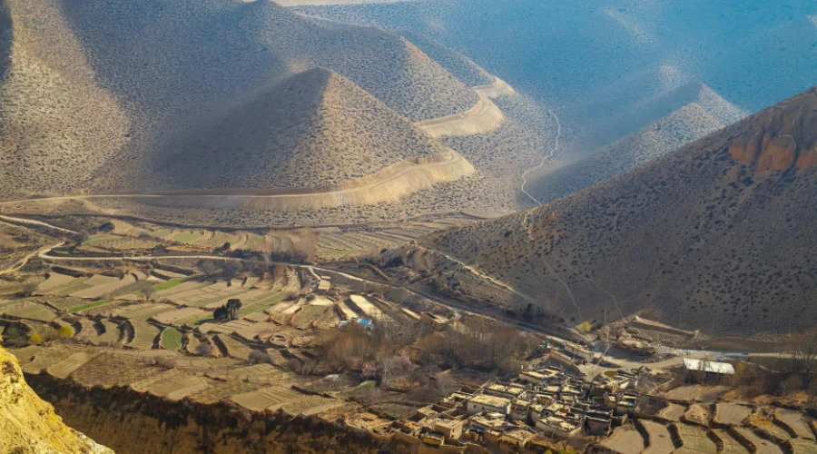
Most probably, when you think of landscapes in Nepal, you imagine verdant forests in the lower section and staggering mountains, but the Upper Mustang Nepal landscape will change your perspective. Instead of dense forests and snow-covered trails, this region opens into a vast, high-altitude desert shaped by wind, time, and isolation.
The landscape of Mustang is featured with vast, windswept canyons, surrounded by towering cliffs, painted in shapes of red, ochre, and deep amber. Trekking in this region feels raw and more authentic.
Located in the Annapurna region of Nepal, in the trans-Himalayan belt, Upper Mustang presents a dramatic scene of deep gorges, eroded cliffs, and endless dry terrain. These stark variations are what make the Upper Mustang Nepal landscape unique and truly captivating.
These Upper Mustang landscapes compel every traveler to stop for a moment, take a deep breath, reflect in silence, and truly connect with the land, feeling closer to Tibet than Nepal.
It’s not just a place you see; it’s a place you experience.
The Upper Mustang region was sealed from the outside world until 1992. Tourists were only allowed to visit this sealed region after obtaining a Restricted Area Permit (RAP), further making the region mysterious and alluring.
Due to its restricted status, the landscape of Mustang preserved its ancient geology, rich culture, and strong spiritual essence, almost untouched by modern influences.
Why the Upper Mustang Landscape Is So Unique?
This unique Upper Mustang landscape is due to its rare geographical and climatic position.
Located in the northern part of the country, bordering Tibet, this region lies in the rain shadow of the Annapurna and Dhaulagiri ranges. These massive mountains act as a natural barrier, blocking the monsoon clouds, leaving Upper Mustang with very little rainfall throughout the year.

Because of this, the Upper Mustang Nepal Landscape has developed into a dry, desert-like terrain. Approximately above 3,500 meters (11,483 ft), the terrain is mostly barren valleys, eroded cliffs, and vast open spaces, shaped by wind rather than water.
This is what gives rise to the distinctive Upper Mustang Nepal desert landscape. Due to very little rainfall, it has preserved ancient geological formations and created a terrain that feels frozen in time.
For centuries, the region remained part of the former Upper Mustang Kingdom of Lo. This restricted status, which still is, helped preserve not just the land, but also the culture and spiritual identity of the region.
Furthermore, Upper Mustang receives less than 200 millimeters of rainfall annually, creating a cold, high-altitude desert. It makes Upper Mustang Trek the only trek in Nepal that remains dry, restricted, and fully accessible even during the monsoon season (generally June to August).
As you cross the checkpoint at Kagbeni and head north into Upper Mustang, you can instantly experience the change in landscape. The greens disappear. The moisture vanishes from the air. Winds become strong, with sand blowing along with them. This gives rise to the Upper Mustang desert landscape.
Formation of the Upper Mustang Nepal Landscape
Every single layer of wind-swept rock and every canyon wall reveals how the Upper Mustang Nepal landscape formed. Understanding this geology makes the landscape even more fascinating.
It might be difficult to believe, but this arid, rugged land of Upper Mustang was once the floor of a shallow ocean, just like Mount Everest.
Millions of years ago, even before the Himalayas existed, this entire region lay beneath the ancient Tethys Sea. When the Indian tectonic plate began its slow, relentless collision with the Eurasian plate, the seafloor was thrust upward, folded, and compressed into the highest mountain ranges on Earth.
The evidence of this ancient ocean is still visible in the form of “shaligram” fossils. Shaligram is a black, ammonite-shaped stone found in the bed of the Kali Gandaki River, revered as a manifestation of Lord Vishnu for Hindu pilgrims.

Over millions of years, tectonic plate movement raised the land, and rivers, wind, and glaciers shaped the Upper Mustang landscape we see today.
The Kali Gandaki River, one of the most geologically ancient rivers in the world (estimated to be around 80 million years old), carved the deepest gorge on earth, Kali Gandaki Gorge. The gorge separates Dhaulagiri (8,167 m/26,795 ft) on the west and Annapurna I (8,091 m/26,545 ft) on the east.
These geological phenomena, tectonic uplift, river erosion, glacial carving, and constant wind, are responsible for this dramatic Upper Mustang Nepal landscape.
Every canyon, every cliff, every colored rock layer you see today tells the story that stretches back through deep time.
Key Landscape Features of Upper Mustang
The Upper Mustang Nepal landscape is not one single visual experience. It is a collection of distinct, remarkable features that come together to create something that cannot be replicated anywhere else.
Here is a closer look at what makes each of these features so special.
Desert Terrain: Nepal’s Hidden Arid World
The first, most notable thing that you’ll notice about the Upper Mustang landscape is its vast, dry, desert-like terrain.
Unlike the enclosed, forested valleys of the Annapurna Circuit or the icy, glaciated terrain of the Everest region, Upper Mustang spreads wide and bare across a high plateau.
Every direction you look, you see barren hills. The landscapes often remind travellers of trekking in Ladakh, with its dramatic mountains, dry valleys, and high-altitude desert scenery. The sky feels enormous, and the silence, only broken by wind and fluttering prayer flags, is profound.
At first glance, the land appears barren, but as you slowly explore it, it becomes more powerful and meaningful.
The trails here follow ancient salt trade routes that connected Nepal with Tibet for centuries. These paths wind through dry riverbeds, past towering canyon walls, and across windswept plateaus.
The villages along the route are small and compact, with houses built using mud-brick. These houses bled so perfectly into their surroundings that, from a distance, they look like natural rock formations.
It is these small things, too, villages blending with nature, a place where human civilization adapts to its environment, that make even this desert terrain of Upper Mustang captivating.

Unique Geology: Layers of Time Carved into Earth
The geology of the Upper Mustang Nepal landscape, which was once part of an ancient ocean, is now one of the driest and most barren lands in Nepal. Today, the cliffs and hills reveal layers of sediment that have been lifted, folded, and shaped over time.
Kali Gandaki River erosion has formed canyons that reveal cross-sections of the Earth’s crust in different colors and detail. Meanwhile, wind carved softer rock into pillars, arches, and hollowed walls.
These natural phenomena gave rise to the unique, surreal geology of the Upper Mustang landscape, which almost feels alien. This makes the landscape not just visually stunning, but also scientifically fascinating.
No two sections of the cliff look quite the same, and the colors shift noticeably as the light changes through the day.
Red Cliffs of Dhakmar: Nature’s Masterpiece
Among all the highlights of the Upper Mustang Nepal Landscape, the red cliffs of Dhakmar stand out as one of the most unforgettable.
Sitting between the village of Ghami and the ancient Ghar Gumba (Lo-Gekar Monastery), these formations are composed of sedimentary rock with an unusually high concentration of iron oxide, giving them their vivid, almost burning red color.
The cliff structure stretches over 2 km (1.25 miles) and can be seen clearly from the Jomsom-Korala Highway near Ghami. At sunrise, the hillside appears to glow from within in shades of deep red and burnt orange.
These cliffs aren’t just a geological feature; they are related to local culture and legends. It is believed that when Guru Rinpoche (Padmasambhava) defeated a demon in the 8th century and established Lo-Gekar Monastery, the demon’s blood stained the hillside permanently red. The demon’s bones were buried under a chorten, and his remains are said to have formed the very hill that glows today.
About 1,200 years old Dhakmar Gompa, perched on a cliff-edge, deepens the sacred atmosphere further. They are an emotional experience, often becoming a favorite moment for trekkers exploring the landscape of Mustang.
Ancient Caves: Mystery Within the Cliffs
One of the most mysterious elements of the Upper Mustang Nepal landscape is the presence of thousands of ancient caves, carved into cliff faces that seem impossible to reach without modern equipment.
Believed to have been first carved around 2,000 years ago, some of these caves are located as high as 50 meters (164 ft). These caves keep people wondering how ancient people once accessed them.
One of the most prominent cave systems is the “Chhoser Cave” with over 50 rooms. The cave’s excavations uncovered human remains dating back approximately 3,000 years.
Originally, these caves were constructed as burial chambers; later, they were used as shelter during the Maoist war and eventually became Buddhist meditation retreats. Today, they remain a powerful reminder that this seemingly empty landscape has been home to human life and culture for centuries.
Many caves contain wall paintings of Buddhist deities, mandalas, and narrative scenes in mineral pigments.
The cliffs around Dhakmar feature hundreds of mini caves, which the local government has transformed into a geo-park with safety railings. If you want to, you can explore them, adding more meaning to your visit.
Oases of Greenery: Life in the Desert
In the middle of the Upper Mustang desert landscape, the presence of villages with green patches can feel genuinely shocking. For over 800 years, the Loba tribe has been utilizing glacier meltwater through stone aqueducts and hand-dug irrigation canals. The water is used to irrigate barley, buckwheat, and mustard terraces, which bring life to the desert.
The villages of Ghami, Tsarang, Tangbe, and Chhusang are located amongst these farms. During the growing season, these villages become a major highlight of the region, filled with green against the surrounding red and ochre-colored cliffs.
Furthermore, in spring, pink and white blossoms of apple and apricot orchards add a little seasonal color to the barren, brown landscape.
These scenes along the Upper Mustang Trek make the route more fascinating. These oases show how aboriginal people have adapted to the harsh yet beautiful environment in the Upper Mustang desert region.

Mountain Vistas: Beyond the Desert
Although the Upper Mustang is known for its desert-like terrain, it also offers some of the best views of the Himalayan giants.
From various viewpoints along the Upper Mustang Trek route, trekkers can see peaks like Mustang Trek, Dhaulagiri (8,167 m/26,795 ft), Annapurna I (8,091 m/26,545 ft), Nilgiri (7,061 m/23,166 ft), Tilicho Peak (7,134 m/23,406 ft), and Manaslu (8,163 m/26,781 ft).
On a clear day, because of the dry, clear air of the trans-Himalayan plateau, these peaks appear really beautiful. This rare combination, desert valleys with a Himalayan backdrop, creates a stunning contrast, making the landscape visually unique.
You walk through the remote, traditional villages in the Upper Mustang region, along with snow-capped mountain views.
Trekkers can enjoy a 360° panoramic view from one of the viewpoints, like Ghami/Ghemi La Pass (3,765 m/12,352 ft).
Cultural Connection with Upper Mustang Landscape
The Upper Mustang region is deeply influenced by Tibetan Buddhist culture. As you walk through villages in Upper Mustang, you can see long mani walls, prayer flags, and chortens standing at crossroads and village entrances.
Mani walls, made of flat stones inscribed with the Buddhist mantra “Om Mani Padme Hum”, lead trekkers along the route. Prayer flags flutter along the route and in villages, connecting the terrain to the sky above.
In research conducted at the CIPA Symposium in Seoul in 2025, Lo Manthang’s landscape was studied using geo-visualization and a Thematic Behavior Model (TBM). The research showed that where these cultural monuments, like monasteries, mani walls, and caves, were placed directly mirrored the shape of the natural terrain.
This research also recognized Lo Manthang as a UNESCO Tentative Heritage Site and part of the Silk Roads’ Lumbini-Mustang corridor.
All these elements together show how nature, spirituality, and daily life go hand in hand in Upper Mustang. It creates a landscape that is not only eye-pleasing but also deeply meaningful to experience.
Villages That Define the Landscape
The villages along the Upper Mustang Trek aren’t just resting spots but are a wholesome experience. They are what make your trek memorable, and Upper Mustang’s barren landscape lively.
Each village along the route feels like a part of the landscape itself. These villages along the trek route offer an insight into how life in such harsh conditions has adapted.
Kagbeni
The transition point and gateway of Upper Mustang, Kagbeni (2,800 m/9,186 ft), has narrow alleyways, an ancient red-walled monastery, and flat-roofed mud-brick houses. This marks the last point at which the landscape still feels familiar before entering the rugged Upper Mustang terrain.

As you move towards the north of Kagbeni, the green terraces and willow trees transform into the arid open terrain of the Upper Mustang desert landscape.
The village is also associated with Hindu tradition: Sarad/Shraddha (an annual Hindu ritual done in the respect of deceased ancestors), at the confluence of the Kali Gandaki River. This village is also the point for Shaligram fossils, sacred for Hindu pilgrims.
Additionally, if you want to add a little bit of spirituality to your trip, you can take a detour from Kagbeni towards the holy Muktinath Temple. It is a sacred temple for Buddhist and Hindu pilgrims. Or, you can even attempt the clockwise Annapurna Circuit Trek via Thorong La Pass.

Ghami/Ghemi
Situated at around 3,510 meters (11,515 ft), Ghami is known for its longest Mani Wall, stretching over 300 meters (984 ft). This long mani wall lies about half an hour away from the village, between Ghami and Dhakmar.
Ghami offers a perfect blend of spirituality with the environment, surrounded by terraced fields of barley, buckwheat, and mustard, framed by wind-eroded cliffs.

Charang/Tsarang, a scenic village
Situated at an elevation of around 3,560 meters (11,679 ft), Charang is the second-largest village in the Upper Mustang region. It used to be the commanding fortress, a former center of power in the Upper Mustang kingdom of Lo.
At the edge of the village lies a crimson monastery, surrounded by terrace fields. The Tsarang Monastery holds ancient Buddhist scriptures, wall paintings, and a library of rare manuscripts documenting the history of the Mustang Kingdom. Likewise, the red palace nearby, once a royal residence, still stands firm against the desert winds.
Lo Manthang, the forbidden kingdom of Nepal
The forbidden kingdom of Nepal, Lo Manthang, is a walled capital of the Kingdom of Lo.
Situated at 3,840 meters (12,598 ft) at the edge of the Tibetan Plateau. Lo Manthang is enclosed by 6 meter high (20 ft) mud-brick walls.
It contains a labyrinth of narrow alleys, a royal palace, and four major monasteries.
This UNESCO Tentative Heritage Site (2019) encompasses agricultural fields, ancient trade routes, cave systems, and an open desert plateau. It is a different world in itself.

Other Notable Villages Along the Route Defining the Upper Mustang Landscape
There are several other smaller villages en route from Kagbeni to Lo Manthang, small yet equally beautiful villages. Each village is shaped by the same desert winds, ancient trade history, and Tibetan Buddhist culture that shaped the entire Upper Mustang Nepal landscape.
The first village that travelers encounter after Kagbeni is the Tangbe, known for its visually striking red, black, and white chortens and narrow maze-like alleys.
Likewise, Chussang is another major village situated at the confluence of the Kali Gandaki and Narsing Khola. The village is widely popular for its dramatic red cliffs and sky caves carved into the canyon walls.
Chele is the first major overnight stop inside Upper Mustang, which sits on a clifftop above the river gorge.
Furthermore, Samar is characterized by its rare juniper trees and Chungsi Cave nearby, where Guru Rinpoche is believed to have meditated. Then comes the Syangboche village, which is considered one of the most remote settlements on this route. It is a small cluster of teahouses between two high passes.
Between Syangboche and Ghami, Ghiling village sits at the historic crossroads of four ancient trade routes connecting the Upper Mustang kingdom of Lo with Tibet.
Cultural Landscape: Where Nature Meets History
The Upper Mustang Nepal landscape and culture go hand in hand. The concept of a cultural landscape is clearly visible here, where human activity, history, and environment are deeply connected.
For over a thousand years, the Loba people have shaped the terrain and tradition. Chortens on every hilltop, long mani walls, monasteries near every village, and ancient irrigation channels carrying glacial meltwater are proof that life and culture are inseparable parts of this challenging Upper Mustang landscape.
The red cliffs, caves carved into cliff walls, river system, and so on, each natural element is directly connected to ancient tradition and belief.
Winds aren’t just erosion; they carry the prayers of thousands of fluttering prayer flags and tolling prayer bells.
The Kali Gandaki, which shaped the deep gorges and layered rock canyons, isn’t just a simple water system. It is connected with millions of years of geological history and holds deep spiritual significance in Hindu tradition.
The landscape is not just shaped by nature, but also by centuries of human adaptation. This makes Upper Mustang one of the most meaningful travel experiences in Nepal.
What Makes Upper Mustang Different from Everest and Annapurna?
The Everest region is famous among its visitors for glacial terrain, towering icefalls, and the deep-rooted Sherpa culture of the Khumbu valley. Meanwhile, the Annapurna region represents an extraordinary diversity, from subtropical lowlands to alpine meadows.
On the other hand, Upper Mustang lies entirely in the rain shadow of the Annapurna and Dhaulagiri ranges. It is one of the few trekking destinations in Nepal that stays dry and accessible even during the monsoon season.
Where Everest and Annapurna are about crossing high-altitude passes and navigating high-altitude locations, Upper Mustang is about exploration. The maximum elevation that you reach during the Upper Mustang Trek is 4,230 meters (13,878 ft).
Where Everest and Annapurna are popular among global trekkers for their glaciers, waterfalls, and dense forests, the landscape of Upper Mustang impresses with colored canyon walls, ancient cave systems, wind-carved cliffs, and vast, high-altitude desert.
Neither region offers a region, so it is influenced by a cultural landscape that earned UNESCO Tentative Heritage recognition.
Upper Mustang is not a harder or easier version of those two regions. It is simply something else entirely.
Therefore, if you are looking for a trek with fewer crowds, less commercialization, and a stronger sense of preserved culture, then Upper Mustang might be just the right choice for you.
This is exactly why many travelers choose Upper Mustang over Everest or Annapurna.

Final Thoughts: A Landscape Unlike Any Other
The Upper Mustang landscape in Nepal is not just unique; it is unforgettable. From its desert terrain and glowing cliffs to its ancient caves and cultural depth, every part of this region tells a story.
So, if you are searching for a destination that goes beyond typical trekking experiences, the Upper Mustang Nepal Landscape offers a journey into a world where nature, history, and culture exist in perfect balance. It is a place that doesn’t just impress you, it stays with you long after you leave.
Loading...
related post


Author

Samyog Shrestha is a travel enthusiast and an excellent content writer at Himalayan Masters, the face behind the amazing content who likes to learn from experience.


Leave Your Comment