




Top 10 Manaslu Mountain Facts That Will Surprise You
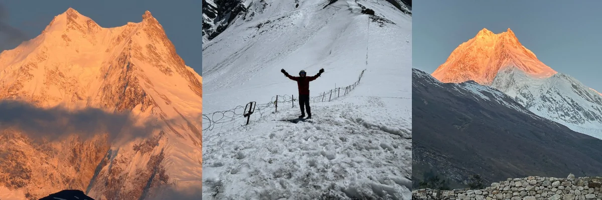
Mount Manaslu, standing at 8,163 m (26,781 ft), is the eighth-highest mountain in the world. It lies in the Mansiri Himal of the Nepal Himalayas, in Gorkha District, Gandaki Province, Nepal.
The Mansiri Himal also includes other high-altitude peaks like Ngadi Chuli 7,871 m (25,823 ft), ranked 20th highest globally, and Himalchuli 7,893 m (25,896 ft), which is ranked 18th highest globally.
The Manaslu Circuit Trek is a complete around-the-mountain trail that takes trekkers past the massive Mount Manaslu. It gives a complete picture of how the mountain feeds the ecosystem and supports the lives of local people. The trek offers deep insights and experience even for beginner trekkers.
Here are some quick Manaslu facts related to its geography, history and significance.
- Elevation: 8,163 m (26,781 ft)
- Rank: 8th highest mountain in the world
- Location: Gorkha District, Nepal
- Mountain range: Mansiri Himal
- First Ascent: 1956, by Toshio Imanishi and Gyaltsen Norbu, part of a Japanese expedition
- First Female Ascent: 1974, by Naoko Nakaseko, Mieko Mori and Masako Uchida, as part of a Japanese women’s expedition
- First Winter Ascent: 12 January 1984, by Polish climbers Maciej Berbeka and Ryszard Gajewski.
- Nepali Name: Manaslu, meaning “Mountain of the Spirit”
- Best known trek: Manaslu Circuit Trek
- Conservation area: Manaslu Conservation Area
- Highest point on the circuit: Larkya La Pass, around 5,106 m (16,751.97 ft)
- First summit attempt: A Japanese expedition attempted the mountain in 1953 before the successful ascent in 1956.
Why is Manaslu considered one of Nepal’s more remote hidden 8000ers?
Mount Manaslu lies deep in the Gorkha district. This location makes it difficult to see from any major road, city, or typical viewpoint. Everest has Kala Patthar; Annapurna has Poon Hill. Manaslu has fewer accessible viewpoints.
Reaching the Manaslu region requires a multi- day journey crossing through the deeply carved river gorge (Budhi Gandaki River). Trekkers need to embark on a foot journey through villages like Machha Khola, Jagat, Deng, Namrung, and Lho village to catch the first up-close views of Mount Manaslu.
Mount Manaslu as the Mountain of the Spirit
The name Manaslu is derived from the Sanskrit word manasa. The word is associated with the mind, intellect, or soul. It is commonly translated as “Mountain of the Spirit.” The idea of a “spirit mountain” isn’t just a poetic branding; it shows a deep connection between the mountain and the people who live below it. The people who live in the Tsum and Nurbi valley below the mountain believe that the mountain is home to protective gods.
The landscape of Manaslu over the Budhi Gandaki River makes it feel less like a physical barrier and more like a presence. They say the atmosphere provides them with inner peace, resilience, and the feeling of the vastness of the human spirit.
Locally, the mountain also has a different older name: Kutang (also written Kutang Ⅰ). The name comes from a Tibetan word “tang,” which refers to “a flat place.”
The name was used by the Tibetan-speaking communities in the Nurbi and Tsum valleys (valleys below the mountain) who have lived there for a very long time.
Mount Manaslu as a living deity
To the local communities, Mount Manaslu has a deep cultural significance. It is not merely a geological formation of rock and ice, but a living deity and the protector of the land. Local communities regard the mountain as a sacred, living entity that looks over the land, controls the weather, and influences the agricultural cycle.
For generations, the locals have coexisted with the mountain through a deep bond of sacred law, under the belief that the peak possesses a conscious presence.
The Puja Ceremony: Asking the Mountain for Safe Passage
Many expedition teams perform a Tibetan-Buddhist ceremony, asking the mountain deity for safe passage before setting foot on its slope. For many expedition teams, Puja is an important traditional ceremony performed before climbing.
A Lama or Buddhist religious practitioner may come to the Manaslu Base Camp to lead the ceremony. The team builds a stone platform with a small furnace. They burn juniper plants and incense during the ritual. The Lama then chants mantras and makes offerings (rice, food, and alcohol are traditional elements).
The team places climbing gear like ice axes, boots, crampons, and ropes beside the altar to be blessed before it touches the Mountain. The Lama sometimes ties red protection thread around the climbers’ wrists or necks.
The ceremony helps the climbers, Sherpa guides, and support staff to come together before the expedition. They believe successful expeditions depend on trust and shared ritual, not just gear and fitness.
A Century of Triumph and Tragedy on Manaslu
The route to the summit of Mount Manaslu was paved with years of heartbreak, harsh retreats, and cultural clashes with local villagers. Here is the lost story of pre-1956 expeditions that pushed the boundaries of human endurance and diplomacy to the absolute.
How was the Northeast Face Explored?
In the year 1950, British explorer H.W. Tilman explored the Manaslu region along with his team. His team mapped the area and found a path to the summit via the Northeast Face.
The Japanese scouting team obtained this information in 1952 A.D., and managed to establish the approach for later attempts.
What was the First Summit Push?
Led by Y. Mita, a Japanese expedition team made a serious attempt to the peak of Manaslu in the year 1953 AD. The team laboriously set up a series of high-altitude camps.
The team reached approximately 7,750 m (25,426 ft) before retreating because of harsh weather conditions.
What happened during the Pungyen Monastery Incident?
When a Japanese team returned in 1954 AD, they faced a strong backlash from the local villagers. In the year between expeditions, a massive avalanche swept down the mountain, destroying the historic Pungyen Monastery and taking the lives of several locals.

Many residents inferred the disaster as a result of disturbing the mountain deity. Local opposition forced the team to return.
How was Peace Restored?
In 1955, the Japanese Alpine Club launched a diplomatic mission to win the local trust. They provided funds for the reconstruction of the ruined monastery and sent an advance team to mend relationships. The locals granted permission for the climbers to return the following year.
How was the First Ascent Achieved?
A massive Japanese team led by Yuko Maki established a series of camps on the northeast face.
First Summit: On May 9, 1956 AD, Toshio Imanishi and Sherpa Gyalzen Norbu made history by becoming the first people to stand on the summit.
Two days later, teammates Kiichiro Kato and Minoru Higeta also reached the summit, proving the absolute success of the expedition.
The achievement marked an important turning point in the history of Japanese expeditions.
What Happened During the Women’s Expedition to Manaslu?
In 1974 AD, a Japanese women’s expedition made history with Naoko Nakaseko, Mieko Mori and Masako Uchida becoming the first women to summit an 8,000-meter peak, proving that female climbers could also conquer the ultimate high-altitude limits of the Himalayas.
The True Summit Controversy
The last ascent of Mount Manaslu’s true summit before 2021 was in 1976.
At the top, the actual summit of Manaslu is very small and narrow and can hold only a couple of climbers at a time. But the fore-summit is a broad, stable snow shelf. Many climbers stopped at a prominent fore-summit rather than traversing to the highest point.
Because every team left their prayer flags at a turnaround point (the fore-summit), it looked like the top. For many years, many climbers mistook the prominent fore-summit for the true highest summit.
In 2021, drone imagery captured by Australian adventurer Jackson Groves during an Imagine Nepal expedition clearly documented the difference between the false summit and the real highest point.
2021 drone footage of Mount Manaslu sparked a huge domino effect and caused a major revision in how Manaslu summits were recorded.
A 22-member team reached the true summit in 2021. Mingma Gyalje Sherpa led the team and made the climb together to the true summit and established the route used to access the highest point.
Why is Manaslu called the “Killer Mountain?”
The technical difficulties, extreme climate, frequent avalanches, and high altitude are major reasons for the high fatality rate on Manaslu. Older statistics showed a much higher death-to-summit ratio than more recent records.
The mountain is highly prone to avalanches due to Steep slopes, hanging glaciers, and unstable seracs above climbing routes.
In the year 1972, an avalanche struck a Korean expedition, taking the lives of 15 people, 10 of whom were Nepali support staff.
A similar incident happened in the year 2012, when an avalanche hit Camp 3 at roughly 7,000 m (22,966 ft), killing 11 climbers in a single event and becoming one of the deadliest incidents in Manaslu’s climbing history.
Likewise, in the year 2022, American ski mountaineer Hilaree Nelson died after a fall while descending from the summit. Around the same period, Nepali guide Anup Rai also lost his life in a separate avalanche accident on the mountain.
These events prove that Manaslu remains a technically and environmentally hazardous mountain.
Why has the fatality rate dropped on Mount Manaslu?
Infrastructure and availability of information have helped the fatality rate decrease. Improved forecasting, route preparation, communication, and rescue capabilities have contributed to changes in climbing the mountain safely, although Manaslu remains hazardous.
However, these improved technologies do not guarantee the elimination of the mountain’s natural hazards. Avalanches, severe weather, unstable snow and ice, and high-altitude conditions pose significant risks.
The GLOF (Glacial Lake Outburst Flood) Probability: Tracking Manaslu’s Glacial Lakes
Manaslu region has several glacial lakes that have a high risk of GLOF (Glacial Lake Outburst Flood) hazards. Glacier retreat and changing lake conditions can alter those risks.
The Manaslu region consists of glaciers such as Manaslu, Punggen, and Thulagi glaciers and many others, together with glacial lakes such as Birendra Tal and Thulagi Lake.
Manaslu Glacier
It belongs to the distinct Mount Manaslu itself and is visible up close during the Manaslu Base Camp trek. It contributes to glacial lakes like Birendra Tal near Samagaun.
Pungyen Glacier
The glacier falls from the eastern and southern slopes of Mount Manaslu. It lies directly below the historic Pungyen Gompa monastery.
The ice melts cross the local trekking trails near Samagaun and Shyalla village before merging into the Budhi Gandaki River basin.
Thulagi Glacier and Thulagi Lake
Thulagi Glacier and the Thulagi Lake (locally known as Dona Tal) sit southwest of Mount Manaslu in the Manang district. The Lake lies at the foot of the glacier. The continuous melt from the glacier is the primary source feeding the lake.
International Center for Integrated Mountain Development (ICIMOD) identifies Thulagi Lake as one of the potentially dangerous glacial lakes in the Himalayas. It flows into the Marsyangdi River basin.
Birendra Tal
It is located in the Gorkha district inside the Manaslu Conservation Area. The glacial lake sits near the northeastern base of Mount Manaslu. The lake is fed by the melting of the Manaslu Glacier.

The hazard associated with any glacial lake depends on Glacier movement, Lake size and volume, Ice or rock avalanches, and temperature and precipitation conditions.
Regional climate warming accelerates ice melt and slope instability, which increases the likelihood and hazard of catastrophic flash floods, avalanches, and debris flows. As these high-elevation glaciers shrink, temperature changes greatly increase the likelihood of rockfalls and landslides.
These glaciers are on some of the steepest slopes in the world. Any changes in their ice greatly increase the risk of sudden, unpredictable disasters. As the climate warms, the overall risk to life, homes and infrastructure rises substantially for communities living in the valleys below.
How Can You Feel Mount Manaslu Up Close As a Beginner?
As a beginner, you can get a close-up view of Mount Manaslu and its region from Manaslu Base Camp or from Pungyen Monastery and Birendra Tal (Lake). On this trek, you can observe the Mountain while also taking a close look at the culture, tradition, festivals, and lifestyle of the local people.
Where do you feel closeness with the Mountain?
The following locations on the Manaslu Mountain offer an up close view of Manaslu Mountain, so close you can also touch it.
Manaslu Base Camp: The base camp sits right next to the mountain. You’re not just looking at the mountain but standing on it. Because it is not commercialized like the other regions, the feeling of closeness is deeply personal.

Birendra Tal: This glacial lake is a short, steep hike from Samagaun and reflects the north face of Mount Manaslu in its still water.
Pungyen Gompa: An old historic monastery hidden below the east face of the mountain provides a scenic, face-to-face view of the Mountain up close.
Shyala Village: Shyala village sits along the main Manaslu Circuit route, surrounded by yaks grazing with the towering view of the mountain right in front of you. It offers impressive views of the surrounding mountains.
How does Mount Manaslu feed and support the ecosystem?
Mount Manaslu and the surrounding Manaslu Conservation Area play a major and multifaceted role in biodiversity, hydrology, and local climate regulation. It helps sustain the regional and global ecosystem.
The Manaslu Conservation Area covers approximately 1,663 sq Km (642 sq miles). It is located at an altitude from about 600 m (1,968 ft) to 8,163 m (26,781 ft). The conservation area supports diverse wildlife and vegetation from lower valleys to high Himalayan environments.

The major headwaters are mountain glaciers and seasonal snowpacks. They slowly release the meltwater into major river systems; this steady year-round flow of freshwater provides essential support for aquatic life, forests, and agricultural lands during the dry season.
Manaslu region spans from subtropical valleys to alpine zones. Lower valleys contain forests and agricultural landscapes, while higher elevations include alpine meadows, glaciers, and permanent snow.
It influences regional monsoon patterns, forcing moisture-laden clouds to precipitate, which nourishes the entire hills and agricultural soil.
The variation in altitude provides habitat for a wide range of animal and plant species and contributes to the ecological preservation and importance of the conservation area.
FAQs
Where does Manaslu Circuit Trek take place?
What is the best season for the Manaslu Circuit Trek?
Is the Manaslu region protected?
What is special about the Manaslu region?
What wildlife can be found in the Manaslu region?
What is the difference between Manaslu climbing and the Manaslu Circuit Trek?
Which is the highest point of Manaslu Cicuit Trek?
Are guides manadatory?
What permits do you need?
Is the Manaslu Circuit Trek safe?
How do I get help in an emergency?
Loading...
related post


Author

Panjum Tamang is a travel content writer with deep enthusiasm for destination research and cultural exploration developed from her current major Meteorology in university. She translates immersive travel experiences into pragmatic and actionable content.


Leave Your Comment