




Manaslu Conservation Area: A Complete Trekking Guide
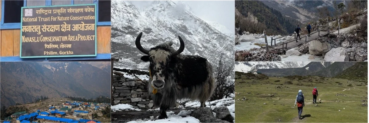
Manaslu Conservation Area is one of the more remote protected areas in Nepal, covering 1663 sq. km. of mountains, forests, rivers, and high Himalayan valleys in Gorkha District. It was established in 1998 and extends from approximately 600 meters above sea level to the peak of Mount Manaslu, the world’s 8th-highest peak at 8163 meters. Around 9,000 residents live here. Exotic animals found here include musk deer, Himalayan tahr, and snow leopards.
But the Manaslu Conservation Area is more than a protected area on a map. Its geographical features range from the lower hills to the high Himalayan region, passing through forests, suspension bridges, and villages influenced by Gurung and Tibetan cultures. The conservation area is entered from the main village of Jagat, one of the earliest villages on the Manaslu Circuit.
The Manaslu Conservation Area’s unique character is defined by its wilderness, high mountains, wildlife and living Himalayan communities. Over 2,000 plant species, as well as dozens of mammals, birds, reptiles and butterflies, have been spotted in the area.
We’ll be exploring the location, geography, history, wildlife, and many more things that make the Manaslu region so special. We’ll also cover the entrance fees, trekking permits, and important rules to know before setting off.
Manaslu Conservation Area at a Glance
Before diving deeper, here’s a quick look at the key facts about this Conservation Area.
| Category | Details |
| Location | Northern Gorkha District, Gandaki Province, Nepal |
| Headquaters | Prok |
| Established on | 1998 AD |
| Area covered | 1,663 km² (642 sq mi) |
| Elevation range | 600 m to 8,163 m (1,970 ft to 26,781 ft) |
| Highest point | Mount Manaslu – 8,163 m (26,781 ft) |
| Main entrance | Jagat |
| Managing body | National Trust for Nature Conservation (NTNC), via the Manaslu Conservation Area Project (MCAP) |
| Population | 7000-9000 people |
| Wildlife | 39 mammals, 201 birds, 3 reptiles and 11 butterflies |
| Vegetation | About 2000 species of flowering plants |
| Best season | Spring (March–May) and Autumn (September–November) |
| Major attractions | Manaslu, Larkya La, Tsum Valley, Tibetan-influenced villages |
| Entrance fee | NPR 3,000 for foreign nationals, NPR 1,000 for SAARC nationals, and NPR 100 for Nepali citizens. |
Where Is the Manaslu Conservation Area? Map & Location
The Manaslu Conservation Area is located in northern Gorkha District in the heart of the Himalayas in Nepal. The area includes the entire Chumnubri Rural Municipality, from the lower Budhi Gandaki Valley to the high mountains surrounding Manaslu and the Larkya La.
The conservation area comprises three major areas: Nubri Valley, Kutang, and Tsum Valley.
Samagaun, Lho, and Prok are located in the Nubri Valley and are nearest to Mount Manaslu. The Tsum Valley lies east of Bihi, towards the Tibetan border, and the Kutang Valley runs from the central part of the area around Bihi to the east, including Chumchet and Chhekampar.
Jagat is the main entrance to the Manaslu Conservation Area. It is also the first major permit checkpoint for trekkers on the Manaslu Circuit.
Geography and Topography
Manaslu is located in a unique geographical location. It is bordered by the Tibet Autonomous Region of China to the north and Manang of the Annapurna Conservation Area to the west. This creates a landscape that moves beyond borders, with high altitude ecosystems, wildlife habitats and old trade routes.
The Budhi Gandaki River runs north through the region along the Manaslu Circuit, which is also an historic salt-trade route. The circuit runs roughly 177 km. Local people and traders used this route between Tibet and the lower valleys long before trekkers came. The landscape changes quickly as you gain elevation.
The journey starts in the subtropical forests and terraced fields of Soti Khola; as you head towards Namrung, you pass oak and rhododendron forests. In the higher areas near Lho, the valley is inhabited by blue pine and hemlock. Around Samagaun and Samdo, the forests give way to alpine meadows and some juniper. Further on, the area becomes rocky and snowy close to Larkya La.
Higher up, glaciers, glacial lakes, rocky valleys, and snow-covered peaks become increasingly prominent. Birendra Lake, near Samagaun, is one of the best-known glacial lakes in the region, while the glaciers around Manaslu and the Pungyen area add another dramatic element to the landscape.
In other words, the Manaslu Circuit is not only a journey through the Himalayas. It’s a trip through several different environments, with the scenery changing every few hundred meters.
The Official Map of the Manaslu Conservation Area
The official map of the Manaslu Conservation Area, published by Nepal’s Department of National Parks and Wildlife Conservation, is a good starting point for planning your route. It provides a better understanding of the conservation area, its boundaries, significant settlements, rivers, and surrounding areas before you embark on your journey.

To get a sense of how Mount Manaslu fits into the broader context of the Himalayas, both in terms of what lies in the immediate vicinity and in comparison to the Tibetan Plateau and Annapurna region, you can read Where Is Mount Manaslu Located?
Why Was Manaslu Conservation Area Established in 1998?
Forests, pastures, rivers, and wildlife have always been vital to the livelihoods of the mountain people of the Manaslu region. As tourism increased and pressure on natural resources mounted, Nepal sought to safeguard the region’s natural heritage without separating conservation from the people who already lived there.
That led to the Manaslu Conservation Area being established on December 28, 1998, covering 1,663 sq. km. in the northern part of Gorkha district. This approach allowed local communities to live and work within the protected landscape and take part in its management.
This approach aimed to balance the protection of fragile Himalayan ecosystems, sustainable use of natural resources, cultural heritage, local livelihoods, and ecotourism. This is significant in a region where people have coexisted with the landscape for centuries, and Tibetan Buddhist culture is still prevalent.
This was also part of a wider shift in how Nepal handles protected areas, one that views local people as partners in conservation rather than outsiders. It promotes community participation in forest and wildlife conservation and resource management.
At the same time, it supports tourism growth in ways that can benefit local livelihoods.
MCAP: How the Manaslu Conservation Area Is Managed
The National Trust for Nature Conservation (NTNC) conducts conservation and development activities in the Manaslu Conservation Area through the Manaslu Conservation Area Project (MCAP). The area isn’t simply protected by rangers; its management also involves the people who live here.
NTNC started working in the region in 1997, a year before the conservation area was established, through the Manaslu Ecotourism Development Project, with support from the Government of Nepal and the Asian Development Bank.
After the area was established, NTNC introduced the Integrated Conservation and Development Program (ICDP), focusing on sustainable resource management and community participation. Local groups have since been involved in forest management, anti-poaching, conservation awareness, and community development.
MCAP also supports conservation education and awareness, while biodiversity research and monitoring help build information on wildlife, plants, and socio-economic conditions in the area.
Human-wildlife conflict remains a concern, particularly when snow leopards attack livestock. In 2025, NTNC and Nature and Biodiversity Conservation Union (NABU) began working across the Central Snow Leopard Conservation Landscape, covering both Manaslu and Annapurna, with a focus on reducing human-snow leopard conflict, community involvement, wildlife research and monitoring, and sustainable tourism.
The partnership focused on reducing human-snow leopard conflict, involving local communities, monitoring wildlife, and supporting sustainable tourism.
Biodiversity around Manaslu Conservation Area
Manaslu is not only a region of high peaks and dramatic valleys. Its forests, alpine meadows, and high mountain slopes support a remarkable range of wildlife and plant species, with different animals occupying different parts of the elevation gradient.
The habitat range for Manaslu spans from subtropical river valleys to bare rock in the alpine area, less than 50 km apart. This is the reason the conservation area ticks so many boxes above its weight on biodiversity.
Mammals
The higher parts of the conservation area provide habitat for rare species such as the snow leopard, while lower and mid-elevation forests support musk deer and Himalayan black bear.
As you move into the alpine areas, you may also find blue sheep, Himalayan tahr, Himalayan black bear and Himalayan marmot. Smaller numbers of lynx, red fox, and jackal are also found across the area.

Birds
Similarly, the birdlife is thick, ranging from lowland forest to the snow-line with a total of 110 species recorded. As you ascend, watch for the Himalayan monal, Nepal’s national bird, the snow partridge, the Tibetan snowcock and the golden eagle.
Reptiles and Butterflies
The conservation area also supports 3 species of reptiles and 11 species of butterflies, contributing to the biodiversity across its habitats.
Flora
The Manaslu Conservation Area is also rich in plant diversity, with more than 2,000 plant species across 11 forest types. The vegetation changes noticeably with elevation.
At lower and mid elevations, dense forests cover the valleys and slopes, while higher areas gradually give way to alpine meadows and more open terrain. As the elevation increases further, vegetation becomes increasingly sparse around the rocky slopes and snow-covered areas.
Medicinal plants such as jatamansi are also found in the conservation area and have traditionally been used by local communities. Their collection is managed through MCAP rather than being treated as open access.
Snow Leopards and the Coexistence Problem
The snow leopard is most likely the animal that trekkers hope to see in Manaslu and at the same time the one they are least likely to encounter. It inhabits the high alpine regions above about 3,500 m, dwelling in the rocky slopes and tranquil valleys near Samdo, Nubri, and the areas leading to Larkya La. It is possible to spend several days in prime snow leopard territory and still see nothing but a footprint or a scrape.
In a survey of the Manaslu Conservation Area, 15 snow leopards were recorded in the Tsum and Nubri valleys, comprising 13 adults and two cubs. Blue sheep and Himalayan tahr are their principal wild prey, together with smaller animals like marmots and woolly hares, which also make up part of their diet.
This makes snow leopard conservation not only about protecting the species, but also about helping local communities and wildlife coexist. Through MCAP, NTNC is working on human-snow leopard coexistence through community awareness, conflict mitigation, and wildlife research and monitoring. Better livestock protection and compensation schemes can also help reduce the impact of livestock losses.
Manaslu is part of Nepal’s expanded Central Snow Leopard Conservation Landscape, which also includes the adjoining Annapurna region. In 2025, a national assessment estimated the population of snow leopards in Nepal at 397, highlighting the need to protect their remaining habitat.
You don’t need to see a snow leopard to know you are in its habitat. The high slopes near Samdo and the routes leading to Larkya La are still part of the landscape where these rare cats live. If you happen to spot one, then you must consider yourself very lucky.
People and Culture: Nubri, Tsum, and Centuries of Tibetan Influence
The Manaslu Conservation Area is home to around 9,000 people, representing communities including Brahmin, Gurung, Nubri, Tsum, Tibetan/Bhote, and Lama groups. For generations, their traditions have grown around the mountains. That lifestyle has been influenced by high-altitude agriculture, animal husbandry, commerce and Tibetan Buddhism.
The influence of Tibet becomes more and more obvious as you head farther north. Stone-built villages, Buddhist monasteries, prayer flags, prayer wheels, and mani walls become part of the landscape, particularly in Nubri and Tsum.

Tsum Valley: A Sacred Hidden Valley
Tsum Valley has its own unique character. It was kept a secret from outsiders for generations until it was officially opened to trekkers in 2008. It continues to be known as the “beyul,” or “hidden sacred valley,” and remains of great spiritual significance to locals.
There are several active monasteries within the valley. Mu Gompa, at around 3,705 m, is the highest monastery in Tsum, while Rachen Gompa is home to a community of Buddhist nuns. Further up, Gumba Lungdang sits beneath the Ganesh Himal range, blending the spiritual atmosphere of a remote location with spectacular mountain scenery.
Tsum is also known for its Shyagya tradition, a form of community-based non-violence that places restrictions on activities such as hunting and killing animals. It still has a significant role in the cultural life of the valley.
Nubri Valley: Life in the High Himalayas
The Tibetan Buddhist culture is also powerful further north in the villages of Nubri Valley. The stone houses, monasteries, agricultural fields, and yak pastures surround Samagaun and Samdo, and the mountains provide an imposing backdrop.
Traditionally, life here has depended on a limited variety of crops such as barley, buckwheat, and potatoes, as well as on raising livestock. Yaks are also highly useful for transport, food, and other resources, especially in an area where farms can only be kept in operation for a small portion of the year.
The area’s historic ties to Tibet are also evident in Samdo, near the Tibetan border. The architecture, language, food and religious practices of the region on either side of the border have been defined by trade and cultural interaction.

Culture Along the Trail
Some of the best glimpses of Manaslu’s culture don’t require a separate excursion. They can be found directly next to the path. Mani walls engraved with Buddhist prayers, colorful prayer flags, chortens, and prayer wheels appear throughout the conservation area.
A memorable section along the trail has 108 prayer wheels. We suggest walking clockwise when passing Buddhist monuments, keeping them on your right.
Tourism now gives local families new opportunities through teahouses, lodges, guiding, and other trekking-related work. At the same time, many people continue to farm, raise livestock, and move between higher and lower elevations with the seasons.
To visitors, this “living culture” makes the Manaslu Conservation Area more than just a protected mountain landscape. Here, local people continue to build their communities upon customs, ways of life and faith which have brought them together with the Himalayas over many years.
Major Villages Inside Manaslu Conservation Area
The villages of Manaslu change noticeably as the trail gains height. Lower down, the Budhi Gandaki runs through greener valleys surrounded by forests and steep cliffs. Further north, the landscape becomes more open and rugged, while stone houses, prayer flags, mani walls, and Tibetan Buddhist traditions become a stronger part of everyday village life.
Jagat
At around 1,340 m, Jagat is one of the first significant settlements inside the conservation area. The village sits beside the Budhi Gandaki River and marks the beginning of the more remote section of the trek. From here, the trail passes through forested slopes, waterfalls, suspension bridges, and narrow stretches of the river valley.
Philim
The trail climbs from Jagat towards Philim, a larger Gurung settlement surrounded by terraced fields. The village has broad views across the valley and is one of the more substantial settlements along the lower section of the route. Beyond Philim, the valley gradually becomes narrower and the trail heads deeper into gorge country.
Deng
Deng stands at about 1,860 m along the Budhi Gandaki and is an important overnight stop for trekkers heading towards Upper Manaslu. The landscape around this village feels more enclosed. Forest, cliffs, and the river dominate much of the approach, although the valley begins to open out again beyond the settlement.
Nyak and Bihi
Between Deng and Namrung, smaller settlements such as Nyak and Bihi sit among the wooded hillsides above the river. These villages provide a quieter glimpse of local life before the route enters an area where Tibetan cultural influence becomes increasingly noticeable. They receive fewer trekkers than the larger stops, but that is part of their appeal.
Namrung
Namrung, at around 2,630 m, is where many trekkers begin to notice a clear change in the character of the trail. Stone houses become more common, along with Buddhist monuments, prayer flags, and mani walls. The surrounding mountains also become more prominent as the route moves further into the high country.
Lho
Lho, at roughly 3,180 m, is one of the most scenic villages in upper Manaslu, set beneath towering peaks with traditional stone houses and Buddhist statues nearby.
Shyala
After the more enclosed sections of the trail, Shyala opens into a broad mountain valley at around 3,500 m. The settlement is surrounded by clear views of Manaslu, Himalchuli, and neighboring peaks. Its open setting and mountain backdrop have also made it one of the most photographed villages on the Manaslu Circuit.
Samagaun
At 3,530 m, Samagaun is one of the main settlements in the upper Manaslu area and an important acclimatization stop. The village is also a starting point for side trips to Birendra Lake and Manaslu Base Camp, while its buildings, monasteries, and traditions reflect the long-established culture of Nubri Valley.
Samdo
Samdo, at about 3,875 m, is the last major village before the trail turns toward Dharmasala and the Larkya La Pass. Close to the Tibetan border, it carries strong Tibetan influence in its architecture and way of life, set against barren slopes and high peaks quite different from the greener villages lower down.
Chhekampar, Nile, and Chule
Chhekampar, Nile, and Chule are villages located in Tsum Valley.
The valley has a cultural identity due to its old stone houses and the old Buddhist practices. This makes the Tsum Valley detour particularly worthwhile for trekkers interested in the communities and traditions of the Manaslu Conservation Area.

Trekking routes inside Manaslu Conservation Area
The Manaslu Conservation Area offers several ways to explore its mountains, villages, and rich cultural landscapes. From the well-established Manaslu Circuit to the quieter trails of Tsum Valley and Rupina La, each route offers a different experience of the region.
Manaslu Circuit Trek
The Manaslu Circuit Trek is the most popular trekking route in the region. It starts from Machha Khola and enters the Manaslu Conservation Area at Jagat, then follows the Budhi Gandaki Valley through Deng, Namrung, Lho, Shyala, Samagaun, and Samdo before reaching Larkya La Pass (5,106 m).
Along the way, the trail passes through the Nubri Valley, where Tibetan Buddhist culture, traditional villages, monasteries, and mountain landscapes shape the experience. Accommodation is mainly in local teahouses, with simple rooms and a mix of Nepali and Tibetan-influenced food.
After crossing Larkya La, the trail descends through Bimthang to Dharapani, where it connects with the Annapurna Conservation Area, making the Manaslu Circuit a trek that links two major conservation areas.
If you’re planning this trek, our 13-day Manaslu Circuit Trek itinerary and Manaslu & Tsum Valley Trek Guide provide more information, which will definitely help you plan.
Tsum Valley Trek
The trek to Tsum Valley is centered on one of the most culturally unique valleys in the Manaslu Conservation Area. Tsum, often called a hidden valley, is known for its traditional villages, ancient monasteries and strong Tibetan Buddhist heritage.
The trip takes you through scenic, peaceful mountain villages and eventually leads to the Mu Gompa at an elevation of about 3,700 m. Tsum Valley delivers a more cultural, local experience for trekkers who prefer to focus on local life rather than crossing a high mountain pass.
Rupina La Trek
Rupina La Trek is an off the beaten trail that leads you into one of the less commercial areas of the Manaslu Region. The trail climbs through villages, forests, and high alpine landscapes to Rupina La Pass (4,720 m), with views of the Manaslu and Annapurna ranges.
With fewer trekkers and a more remote character than the classic circuit, Rupina La is a good choice for those seeking a less-explored Himalayan experience. We recommend the Rupina La Trek for experienced trekkers only, as the route involves challenging terrain and high-altitude sections and requires a good level of physical fitness.
Manaslu Circuit Trek with Serang Gompa Stay
For a more cultural version of the classic circuit, Himalayan Masters also offers the 16-day Manaslu Circuit Trek with a stay at Serang Gompa. The itinerary includes a trek to the remote monastery, offering a more tranquil, Buddhist aspect of the region before joining the main route.
The route then continues through the upper Manaslu villages and toward Larkya La, combining the highlights of the classic circuit with an additional cultural experience.
Side Trips Along the Main Routes
The Manaslu trekking routes also offer several worthwhile side trips. From Samagaun, trekkers can walk to Birendra Lake or make the longer hike to Manaslu Base Camp. Another worthwhile stop is Pungyen Gompa, a serene spot with great views of Manaslu. These short trips enable trekkers to see more of the conservation area without altering the main trekking route.
Trekkers can choose to go towards Ganesh Himal Base Camp from Chhekampar as a side trip during their Tsum Valley trek.
Also, combining the Manaslu Circuit and Tsum Valley trek into a longer itinerary gives you a more comprehensive experience of the area.
Getting to Manaslu Conservation Area
Most trekkers reach the Manaslu Conservation Area by road from Kathmandu, traveling through Dhading and Arughat toward Soti Khola or Machha Khola. Depending on road and weather conditions, the journey generally takes around 7–9 hours by jeep or bus. From Machha Khola, the trekking route continues toward Jagat, the main entrance to the Manaslu Conservation Area, where trekkers complete the required entry formalities.
There are no regular flights to the Manaslu Conservation Area. Charter helicopter flights can, however, reach higher settlements such as Samagaun and Samdo, depending on the weather, flight conditions, and the purpose of travel.
Permits and Entry Requirements
Exploring the Manaslu Conservation Area involves several permits and local fees that depend on which part of the region you visit. As of 2026, there has been an important change to the rules for trekking in the restricted areas within the conservation area.
The Two-Trekker Rule is Gone
Until March 2026, the Manaslu Restricted Area Permit (RAP) required at least two foreign trekkers to apply together. On 22 March 2026, the Department of Immigration removed this requirement, allowing an individual trekker to apply for the RAP alone.
However, solo does not mean unguided. A licensed trekking guide is still required, and the restricted-area permit must be arranged through a registered trekking agency.
Required Permits for Manaslu
For foreign visitors exploring the Manaslu Conservation Area, the required permits depend on the route and areas they plan to visit.
Manaslu is a designated restricted trekking area, which means foreign trekkers need a separate Manaslu Restricted Area Permit (RAP) in addition to the Manaslu Conservation Area Permit (MCAP).
The restricted-area rules are in place because of the region’s sensitive location and the need for closer management of trekking activities. Foreign trekkers must travel with a licensed guide, and the RAP has to be arranged through a registered trekking agency.
Depending on your route, you may also need the Chumnubri Rural Municipality fee and the Tsum Valley Restricted Area Permit. These are separate from the MCAP and Manaslu RAP.
Permit fees
The total cost depends on your route, trekking duration, and whether you enter areas such as Tsum Valley. It also depends on the season of your travel. For more information regarding the permits, you can read our detailed guide on Manaslu permits.
If you’re traveling with Himalayan Masters, the required permits will be arranged as part of the trekking process, making the paperwork hassle-free.
Choosing the Best Season for Manaslu
Wondering when the Manaslu Conservation Area is at its best? That really depends on what kind of experience you’re looking for.
Each season reveals a different side of Manaslu, be it the clear mountain views, the rhododendron blooms, the snowy trails, or the quieter paths.
- Autumn (September-November): This season is the classic choice for clear skies, stable weather, and spectacular mountain views. It’s also the busiest time, so popular villages and teahouses can feel lively.
- Spring (March-May): Spring is a great time for colorful rhododendron forests, warmer days, and generally good trail conditions, though afternoons can get cloudy.
- Winter (December-February): Winter is much quieter and beautifully snowy, but a lot colder. Higher trails are generally covered in snow. The trek to Larkya La may become difficult to cross, and some teahouses close due to harsh weather.
- Monsoon (June-August): Monsoon brings greenery, peacefulness, and less crowded conditions, with lower permit costs. Expect rain, leeches, muddy trails, and possible landslides on the lower sections.
For the best overall experience, autumn and spring are the most favorable seasons. But if you’re happy to trade easier conditions for solitude, winter and monsoon offer a much quieter and more adventurous side of the Manaslu Conservation Area.
Manaslu Conservation Area vs. Annapurna Conservation Area: How Are They Different?
Both are major conservation areas in Nepal managed by the NTNC, but the experience of exploring them is quite different. Manaslu is quieter, more remote, and strongly shaped by Tibetan Buddhist culture, while Annapurna is more developed and easier to access.
Here’s a table that’ll help you differentiate them at a glance.
| Details | Manaslu Conservation Area | Annapurna Conservation Area |
| Area covered | 1,663 sq. km | 7,629 sq. km |
| Elevation range | 600-8,163 m | 790-8,091 m |
| Highest peak | Mount Manaslu – 8,163 m | Mount Annapurna I – 8,091 m |
| Established on | 1998 | 1992 |
| Annual foreign visitors | 15,000+ | 500,000+ |
| Guide requirement | Mandatory on restricted trekking routes | Independent trekking allowed |
| Permits required | RAP + MCAP + ACAP + local fees | ACAP |
| Teahouse development | Basic and more spread out | More developed and frequent |
| Cultural character | Strong Tibetan Buddhist influence | Diverse Hindu-Buddhist cultures |
For those seeking solitude, dramatic scenery, and a more immersive cultural experience, Manaslu is the perfect choice. Meanwhile, Annapurna is better suited to those who enjoy more developed trails, more accommodation options, and a more established trekking infrastructure.
Responsible Trekking in a Living Conservation Area
The Manaslu Conservation Area is home to local communities, wildlife, monasteries, and fragile mountain ecosystems. A few simple choices can help protect the environment while showing respect for the people and culture you encounter along the way.
| Do’s | Dont’s |
| Carry a reusable water bottle | Litter or leave waste behind |
| Pack out everything you bring in | Disturb or approach wildlife |
| Stay on designated trails | Remove plants, flowers, or herbs |
| Use refill stations where available | Waste water |
| Remove your shoes before entering monasteries | Touch religious objects without permission |
| Walk clockwise around mani walls and prayer wheels | Step over or climb on mani walls |
| Ask before photographing people | Photograph people without permission |
| Dress respectfully around religious sites | Raise your voice near monasteries or sacred places |
| Support local teahouses, guides, and porters | Bargain aggressively over small amounts |
| Keep noise low and respect local routines | Disturb livestock or local activities |
| Carry reusable toiletries and avoid unnecessary packaging | Leave batteries or other waste behind |
Small actions can make a real difference. Travel lightly, respect local customs, and leave the Manaslu Conservation Area as you found it.

Final Look at Manaslu Conservation Area
The Manaslu Conservation Area is important because it protects a remarkable mix of mountains, forests, wildlife, and biodiversity, while also preserving the cultural heritage of the communities living within it. Conservation here is closely connected with local people, who are involved in natural resource management, conservation awareness, and community development.
For trekkers, this means understanding that Manaslu is not simply a trekking destination. It is a living conservation area, where people, wildlife, and nature share the same landscape. Responsible tourism matters because the choices visitors make can affect the environment and the communities that depend on it.
Whether you are visiting for the Manaslu Circuit, exploring Tsum Valley, or discovering its remote villages and landscapes, there is plenty to experience. We request that you travel responsibly, which will help to maintain the specialness of Manaslu. Please take your time, respect the local cultures, and leave the conservation area as you found it.
FAQs
What is Manaslu Conservation Area?
Where is Manaslu Conservation Area located?
When was Manaslu Conservation Area established?
How large is Manaslu Conservation Area?
Is Manaslu Conservation Area a national park?
What animals are found in Manaslu Conservation Area?
Can you see snow leopards in Manaslu?
Which treks pass through Manaslu Conservation Area?
Is a permit required for Manaslu Conservation Area?
Can you trek Manaslu Conservation Area independently?
What is MCAP?
Who manages Manaslu Conservation Area?
What is the best time to visit Manaslu Conservation Area?
Is Tsum Valley inside Manaslu Conservation Area?
Is Manaslu Circuit inside the conservation area?
How do you get to Manaslu Conservation Area?
What is the entrance fee for Manaslu Conservation Area?
Loading...
related post


Author

Jayanta Neupane is a travel content writer with a genuine passion for exploring, researching, and sharing travel experiences. He enjoys turning firsthand experiences and destination research into engaging, informative, and practical content. With an interest in adventure, trekking, and Nepal’s diverse landscapes and cultures, he focuses on creating authentic content that helps travelers better understand and experience their destinations.


Leave Your Comment