




Where is Mount Manaslu Located?
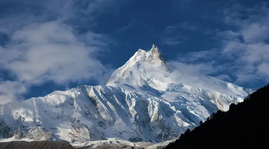
Mount Manaslu rises above the upper Budhi Gandaki Valley, where deep gorges, mountain villages, glaciers, and high Himalayan ridges come together in northern Gorkha district of Gandaki Province within the Mansiri Himal of the Nepal Himalaya.
Mount Manaslu is located at approximately 28°33′01″N latitude and 84°33′42″E longitude. At 8,163 meters (26,781 feet), it is the eighth-highest mountain in the world. The mountain lies inside the Manaslu Conservation Area, which covers 1,663 square kilometers of northern Gorkha.
About Mount Manaslu
Manaslu is one of Nepal’s major 8,000 meter peaks and the highest mountain in the Mansiri Himal range. Its name comes from the Sanskrit word “Manasa,” commonly understood as referring to the spirit or intellect.
The mountain stands in the upper Budhi Gandaki region of northern Gorkha. The landscape changes considerably as the valley rises from the lower hills toward the high Himalaya. River gorges, forests, steep slopes, Tibetan influenced villages, glaciers, and high mountain ridges are all part of the wider Manaslu region.

Manaslu was first climbed on May 9, 1956, by Toshio Imanishi and Gyalzen Norbu, members of a Japanese expedition. It was not the first 8,000 meter mountain to be climbed. Annapurna I was first climbed in 1950, followed by Mount Everest in 1953. Manaslu was the eighth 8,000 meter mountain to be successfully climbed.
The mountain has since become an important destination for mountaineering expeditions and trekking in Nepal.
Where Is Manaslu Located in Nepal?
Administratively, Mount Manaslu is in Gorkha District of Gandaki Province in north-central Nepal. The wider Manaslu region extends through Tsumnubri Rural Municipality, which contains most of the settlements and landscapes associated with the mountain.
Gorkha lies west of Kathmandu and east of the Annapurna region. The Manaslu area is farther north within the district, where the terrain rises toward the Tibetan border.
The main trekking approach follows the Budhi Gandaki River valley. Jagat, Deng, Namrung, Lho, Shyala, Samagaun, and Samdo are among the major settlements along the route toward the high Manaslu region.

Manaslu in the Mansiri Himal
Manaslu belongs to the Mansiri Himal, also called the Manaslu Himal in some references. It forms part of the larger Nepal Himalaya range.
The massif includes several high peaks and ridges around the main summit. Himalchuli and Ngadi Chuli are also part of this broader mountain landscape. The Annapurna massif lies farther west, while Ganesh Himal is found toward the east.
This location gives Manaslu a distinct position between several major Himalayan mountain groups. The mountain itself rises above the upper Budhi Gandaki valley and its surrounding glaciers.
How Close Is Manaslu to the Tibet Border?
The Manaslu region lies close to the Nepal-Tibet border, particularly around the upper Nubri Valley and settlements such as Samdo.
However, Mount Manaslu itself does not sit directly on the international boundary. The northern side of the mountain region extends toward the border, with high passes and valleys connecting the landscape with the Tibetan Plateau.
The proximity to Tibet is also reflected in the culture of the upper villages. Architecture, monasteries, prayer flags, Buddhist practices, and local traditions show strong Tibetan influence.
Where Is Mount Manaslu on the Map?
On a map of Nepal, Manaslu is found in the north-central part of the country. The mountain is east of the Annapurna massif and west of Ganesh Himal. The Manaslu Conservation Area surrounds much of the upper Budhi Gandaki region and includes several valleys leading toward the mountain.

Mountains and Ranges Around Manaslu
Several major Himalayan peaks and ranges surround the Manaslu region. Himalchuli lies to the south of Manaslu and forms part of the same broader mountain landscape.
Ngadi Chuli is another high peak in the surrounding range. Ganesh Himal lies farther east, while the Annapurna massif is located to the west.
The Budhi Gandaki valley separates many of these high mountain landscapes and provides the main trekking approach to Manaslu.
Where Is the Manaslu Conservation Area?
The Manaslu Conservation Area lies in northern Gorkha District and covers 1,663 square kilometers. It was declared a conservation area on December 28, 1998.
The protected area includes Tsumnubri Rural Municipality and covers three broad cultural and geographic areas: the Nubri Valley, Kutang, and Tsum Valley.
The Nubri Valley includes settlements such as Samagaun, Lho, and Prok. Kutang includes villages around Bihi, while Tsum Valley includes Chumchet and Chhekampar.
The conservation area protects a wide range of Himalayan landscapes, from lower forests to high alpine terrain. It is also known for its wildlife, plants, Buddhist monasteries, and traditional villages.
Major Villages Around Mount Manaslu
Jagat is one of the main entry points for the Manaslu trekking region. The trail follows the Budhi Gandaki north from here toward the higher valleys.
Namrung marks a noticeable change in the landscape as the route enters the upper Nubri region. Mountain views become more prominent from this section.
Lho is known for its Buddhist culture and views toward Manaslu. It is also an important overnight stop on the Manaslu Circuit.
Shyala sits in an open mountain setting with views of several surrounding peaks. The village is close to Samagaun.

Samagaun is one of the most important settlements in the upper Manaslu region. Trekkers commonly spend an acclimatization day here, and the village is also the main settlement for people visiting Manaslu Base Camp and Birendra Lake.
Samdo lies farther north at high altitude, close to the Tibetan border. It is the last major settlement before the route continues toward Dharamsala and the Larkya La pass.
How to Reach the Manaslu Region from Kathmandu
There are many ways to reach the Manaslu region. Trekkers start at Kathmandu and go to Dhading Besi via Galchi. They use the Prithvi Highway to get there. From Dhading Besi, the road goes toward Arughat Bazar.
The road goes on to Machha Khola. Another path is Abu Khaireni and Gorkha Bazaar. This path joins the same road at Arughat. It goes on until it reaches Machha Khola.

A trekking approach goes from Gorkha to Barpak. The trail crosses Rupina La to Budhi Gandaki Valley. From Machha Khola, trekkers start the standard circuit. They walk through Jagat, Deng, Namrung, and Lho and pass Shyala and Samagaun on foot.
From Samagaun, the circuit trail diverges from the main circuit trail toward Manaslu Base Camp, reaching the base of Mount Manaslu.
While following the path from Samagaun will lead toward Larkya Pass, which will bring you toward Lamjung district, leaving behind Manaslu Conservation Area and joining Annapurna Conservation Area.
Road Distance to the Manaslu Trailhead
The road distance from Kathmandu to Machha Khola is about 164 km (102 miles). The journey normally takes 7 to 8 hours, depending on traffic, weather, road conditions, and the vehicle.
Manaslu is considerably closer to Kathmandu in a straight line than it is by road and trekking trail. The mountain lies northwest of Kathmandu, but the terrain and river valleys make the actual journey much longer than the map distance suggests.
Trekking Distance to the Upper Manaslu Region
From Machha Khola, several days of trekking are needed to reach Samagaun and the upper Manaslu region. The trail gradually climbs from the lower Budhi Gandaki valley into the high Himalayan landscape.
Where Is Manaslu Base Camp?
Manaslu Base Camp is located above Samagaun on the southern side of Mount Manaslu. It is reached as a side trip from Samagaun rather than directly along the main Manaslu Circuit trail.

The route climbs through increasingly high alpine terrain before reaching the base camp area. The side trip is around 13 km (8 km) round trip, depending on the exact route.
At roughly 4,800 meters, the base camp is considerably higher than Samagaun. Trekkers need to consider altitude and weather before making the trip.
Why Is Manaslu Considered a Challenging 8,000 Meter Peak?
Climbing Manaslu is a serious high-altitude mountaineering undertaking. Its difficulty comes from several factors rather than altitude alone.
Altitude is one of the main challenges. At 8,163 meters, the summit lies in the extreme altitude zone where oxygen levels are very low. Climbers need acclimatization and careful management of their time at high elevations.
Avalanche exposure is another concern. Snow conditions can change quickly on the mountain, and climbers must assess avalanche risk before moving through exposed sections.
Crevasses are present in the glaciated terrain. Climbers need appropriate equipment and experience to travel safely across glacier sections.
Weather can change rapidly at high altitude. Strong winds, snowfall, poor visibility, and very low temperatures can affect climbing plans and summit attempts.
There are also technical climbing sections, including steep snow, ice, and exposed terrain. Climbers need appropriate mountaineering skills, equipment, and experience.
Finally, expedition logistics add another layer of difficulty. Teams need permits, guides, climbing equipment, high-altitude camps, food, fuel, ropes, communication systems, and support staff. The expedition also involves carrying supplies through difficult terrain and planning around weather windows.
Mount Manaslu South Face vs North Face
Mount Manaslu has several large faces and ridges, each with different climbing characteristics. The southern side rises above the upper Budhi Gandaki region and is the side most familiar to trekkers approaching from Samagaun.
The northern side extends toward the Tibetan border and presents a different mountain environment. The summit, ridges, glaciers, and surrounding peaks form a complex massif rather than a single isolated slope.
For trekkers, the southern approach is more relevant because the Manaslu Circuit and the route to Base Camp reach the mountain from this side.
Mount Manaslu Summit and Deaths
Manaslu has a long history of mountaineering accidents and fatalities. The risks include avalanches, falls, altitude-related illness, extreme weather, and difficult glacier terrain.
The first successful ascent took place in 1956, but later expeditions continued to face serious hazards on the mountain. Conditions can vary between climbing seasons, so previous summit success does not remove the risks involved in a new expedition.
Trekking Routes Around Mount Manaslu
|
Route
|
Location
|
Route character
|
Maximum altitude
|
Relationship to Manaslu
|
| Manaslu Circuit Trek | Budhi Gandaki to Dharapani/Tilije | Long circuit with high pass crossing | 5,106 m at Larkya La | Main trekking route around the Manaslu massif |
|
Tsum Valley Trek
|
Eastern side of the Manaslu region | Cultural valley trek with monasteries and villages | Around 3,700 m | Explores a separate valley within the Manaslu Conservation Area |
|
Lower Manaslu Trek
|
Lower Gorkha | Lower-altitude hills and villages | Lower than the main circuit | Explores the southern and lower areas of the Manaslu region |
|
Rupina La Route
|
Southern Manaslu region | Remote and demanding high-pass route | Around 4,600 m | Crosses a less-traveled route south of the main Manaslu Circuit |
The Manaslu Circuit is the best-known trekking route in the area. It passes through the Budhi Gandaki valley, reaches Samagaun and Samdo, crosses the 5,106-meter Larkya La, and descends toward Bimthang and Tilije.
Geography and Physical Features of Mount Manaslu
Manaslu forms part of the Mansiri Himal and consists of a large mountain massif with several ridges and faces. Its upper slopes contain snow and ice, while the lower surroundings include rocky valleys, forests, glaciers, and alpine meadows.
Several glaciers surround the massif. The changing elevation creates a clear contrast between the lower Budhi Gandaki valley and the high mountain terrain around Manaslu.
The main summit rises to 8,163 meters (26,781 ft), with nearby ridges and subsidiary summits forming part of the larger massif. The combination of rock, ice, snow, and glacial terrain makes the geography of Manaslu complex.

History of Mount Manaslu
Mount Manaslu became known internationally through Japanese mountaineering expeditions in the 1950s. The first successful summit was reached in 1956 by Toshio Imanishi and Gyalzen Norbu.
The mountain later became an important expedition peak in Nepal. At the same time, the surrounding valleys developed as trekking destinations, especially after the Manaslu region opened to organized trekking.
Today, the mountain is closely connected with the Manaslu Circuit, Tsum Valley, local tibetan culture, and conservation work within the Manaslu Conservation Area.
For travelers, Manaslu is best understood as a mountain region rather than a single viewpoint. The route from Machha Khola to Samagaun shows how the landscape changes from river valleys and forests to high Himalayan terrain, while the villages along the way provide a clear connection between the geography, culture, and history of northern Gorkha.
Loading...
related post


Author

Swostika is a content writer at Himalayan Masters as well as a travel enthusiast. She loves to travel and learn about different cultures and people. With a love for writing, traveling, and embracing diverse cultures, she is on a journey to explore and inspire through words.


Leave Your Comment